The Tibetan Plateau, often referred to as “Asia’s Water Tower,” plays a critical role in the continent’s hydrological cycle and subsequently impacts the lives of billions of people. This vast, high-altitude region, with an average elevation exceeding 4,500 meters (14,800 feet), is a geographical marvel and an ecological keystone. Its immense scale and unique climatic conditions have fostered a complex system of glaciers, snowpack, and rivers that serve as the lifeblood for numerous major river systems across Asia. Understanding the intricate workings of this region is paramount, not only for the local populations but also for the broader global community concerned with water security and the impacts of climate change.
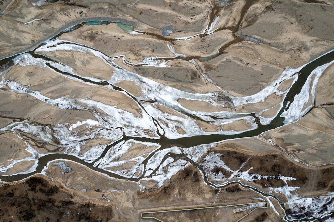
To comprehend the significance of the Tibetan Plateau as Asia’s Water Tower, one must first appreciate its topographical and geographical characteristics. It is not merely a high plain but a complex mosaic of mountain ranges, basins, and expansive grasslands. The sheer scale of the plateau is impressive; it covers an area of approximately 2.5 million square kilometers, making it the largest and highest plateau on Earth. Its geographical position, nestled between some of the world’s most formidable mountain ranges, including the Himalayas to the south, the Kunlun Mountains to the north, and the Karakoram Range to the west, isolates it and contributes to its distinctive climate.
Elevation and Topography
The plateau’s average elevation is a defining characteristic, but its topography is far from uniform. While vast stretches are characterized by rolling grasslands and arid steppes, these are punctuated by towering peaks and deep valleys. The northern and eastern parts of the plateau are dominated by mountainous terrain, featuring ranges such as the Tanggula Mountains and the Kunlun Mountains. These elevations create a colder climate and are significant areas for snow accumulation. Conversely, some basins, like the Qaidam Basin, are lower in elevation and can exhibit more arid conditions. The dramatic changes in elevation across the plateau influence precipitation patterns and the distribution of glaciers and snowpack. Without these varied elevations, the plateau’s capacity to store and release water would be significantly diminished.
Major Mountain Ranges and Their Influence
The surrounding mountain ranges are not merely boundaries; they are active participants in shaping the plateau’s hydrology. The Himalayas, in particular, are a crucial factor. Their immense height creates a formidable barrier that significantly influences atmospheric circulation. This barrier forces moisture-laden air masses from the Indian Ocean to rise, cool, and release precipitation over the southern and eastern edges of the plateau, thereby contributing to its water resources. Similarly, the Kunlun Mountains to the north act as a climatic divide, contributing to the arid conditions of the Tarim Basin to its north. The Karakoram Range, a formidable spur of the Himalayas, is also densely glaciated and plays a vital role in feeding some of the plateau’s major rivers.
Basin Structures and Their Role
Within the plateau, numerous intermontane basins exist, each with its own microclimate and hydrological characteristics. These basins, such as the Qaidam and the Hoh Xil, can act as internal sinks for water or contribute to the overall drainage network. The formation of these basins is a result of tectonic activity over millions of years and influences how water is collected, stored, and eventually discharged. Understanding the hydrological connectivity between these basins and the surrounding mountain ranges is essential for a comprehensive understanding of the plateau’s water management.
The Tibetan Plateau, often referred to as the “Water Tower of Asia,” plays a crucial role in supplying water to millions of people across the continent. Its glaciers and snowmelt feed major rivers such as the Yangtze, Yellow, and Mekong, making it an essential resource for agriculture and drinking water. For a deeper understanding of the environmental challenges facing this vital region, you can read more in this related article: Water Resources and Environmental Changes in the Tibetan Plateau.
The Glacial Jewel of Asia
The Tibetan Plateau is home to a substantial portion of Asia’s glaciers, making it the third-largest ice reservoir on Earth, after the poles. These glaciers are not static features but dynamic entities, acting as colossal frozen reservoirs that release meltwater during warmer months, thus contributing significantly to the summer river flows. Their presence is a testament to the cold, high-altitude environment and their role as natural regulators of water supply is irreplaceable.
Glacier Distribution and Ice Volume
Glaciers are concentrated in the major mountain ranges surrounding and traversing the plateau, with the Himalayas and the Karakoram Range hosting the most extensive ice masses. The eastern and northeastern parts of the plateau also feature significant glaciation, albeit to a lesser extent than the southern and western extremes. The total ice volume is immense, representing a substantial store of freshwater. Studies indicate that the plateau’s glaciers have been a consistent source of meltwater for millennia, supporting the vast river systems that emanate from the region.
The Physics of Glacier Melt and Seasonal Release
Glaciers are formed when snowfall accumulates over long periods, compressing into ice. The melting process is driven by ambient temperature and solar radiation. During the summer months, when temperatures rise, glaciers begin to melt. This meltwater then flows into streams and rivers, augmenting their flow. This seasonal release is particularly crucial in regions where other water sources, such as rainfall, are less reliable during the dry season. The meltwater acts as a buffer, ensuring a more consistent water supply throughout the year. Imagine a slow-dripping faucet that provides a steady stream of water; the glaciers on the Tibetan Plateau function in a similar capacity for Asia’s rivers.
The Importance of Glacial Meltwater for Rivers
The meltwater from the plateau’s glaciers provides a significant and often essential component of the water flow for several of Asia’s most important rivers. During the dry season, when rainfall is scarce, these glacial contributions can be the primary source of water. This makes the glaciers vital for maintaining river flows, supporting agriculture, and providing drinking water to downstream populations. The predictability of this meltwater release, while increasingly being influenced by climate change, has historically allowed for the development of human settlements and agricultural practices in downstream regions.
The Birthplace of Asia’s Great Rivers

The Tibetan Plateau is aptly named “Asia’s Water Tower” because it is the headwaters for numerous major river systems that nourish vast swathes of the continent. These rivers, upon leaving the plateau, become lifelines for millions, supporting ecosystems, agriculture, and economies. The sheer number and importance of these rivers originating from this relatively remote region underscore its critical hydrological function.
The Indus River System
The Indus River, a vital artery for Pakistan and parts of India, traces its origins to the Tibetan Plateau. Its headwaters are fed by glacial meltwater and precipitation that falls on the plateau. The Indus flows through arid regions, making the steady contribution of glacial melt crucial for its sustained flow, supporting one of the world’s major agricultural regions. If the source of a river is polluted or diminished, the entire downstream ecosystem suffers, mirroring the fragility of the Indus’s reliance on its upstream origins.
The Ganges-Brahmaputra Delta
The Ganges and Brahmaputra rivers, which merge to form one of the world’s largest deltas in Bangladesh and India, also originate on the Tibetan Plateau. These rivers are considered sacred by many in India and are fundamental to the livelihoods of hundreds of millions of people. Glacial melt from the Himalayas, which are a part of the greater Tibetan Plateau region, is a significant contributor to their flow, especially during the dry season. The sheer volume of water these rivers carry sustains vast agricultural lands and supports immense biodiversity.
The Mekong River
Flowing through Southeast Asia, the Mekong River is another critical aquatic system that draws a substantial portion of its headwaters from the Tibetan Plateau. This river is a vital resource for agriculture, fisheries, and transportation for countries such as China, Myanmar, Laos, Thailand, Cambodia, and Vietnam. The monsoon rains are important for the Mekong, but glacial and snowmelt from the plateau contributes to its flow, particularly during the initial stages of the wet season.
The Yangtze and Yellow Rivers
In eastern China, the Yangtze and Yellow Rivers, two of the country’s most significant waterways, also originate on the Tibetan Plateau. The Yangtze, the longest river in Asia, is a crucial resource for irrigation, navigation, and hydroelectric power generation. The Yellow River, known for its historically fertile plains, also relies on water originating from the plateau. The combined water supply from these rivers is indispensable for China’s agricultural output and population sustenance.
Climate Change and the Future of Asia’s Water Tower
The Tibetan Plateau, like many high-altitude regions, is experiencing the amplified effects of global climate change. Rising global temperatures are leading to accelerated glacier melt, altered precipitation patterns, and significant shifts in the plateau’s fragile ecosystem. The implications of these changes for the long-term water security of Asia are profound and warrant serious attention and proactive management.
Accelerated Glacier Melt and Reduced Snow Cover
One of the most visible impacts of climate change on the Tibetan Plateau is the accelerated melting of its glaciers. As global temperatures rise, glaciers that have existed for millennia are receding at an unprecedented rate. This leads to an initial increase in meltwater flow, but it is a finite resource. Eventually, as glaciers shrink, the long-term water supply will be reduced. Similarly, snow cover duration is decreasing, impacting the natural storage of water that would otherwise be released gradually.
Shifting Precipitation Patterns and Extreme Weather Events
Climate change is also altering precipitation patterns across the plateau. While some areas might experience increased rainfall, others could face prolonged droughts. The frequency and intensity of extreme weather events, such as floods and landslides, are also on the rise. These shifts can disrupt the delicate balance of the hydrological cycle, leading to unpredictable water availability and increased risks for downstream communities. The unpredictable nature of these events can be likened to a once-reliable clock now ticking erratically.
Impacts on Downstream Water Availability
The cumulative effect of accelerated glacier melt and shifting precipitation patterns is a significant threat to downstream water availability. While initial increased melt might provide more water in the short term, the long-term prognosis is a reduction in the consistent supply from glaciers. This could lead to water scarcity issues for the billions of people who depend on these rivers for drinking water, agriculture, and industrial use. The interconnectedness of the water systems means that changes at the source inevitably propagate downstream.
The Need for Monitoring and Adaptation Strategies
Given the critical role of the Tibetan Plateau in sustaining Asia’s water resources, robust monitoring of its hydrological systems is essential. International cooperation in data collection and research is crucial to understand the ongoing changes and to develop effective adaptation strategies. These strategies must consider the diverse needs of downstream populations and aim to build resilience in water management practices. Failure to address these challenges could have severe geopolitical and humanitarian consequences.
The Tibetan Plateau, often referred to as the “Water Tower of Asia,” plays a crucial role in supplying water to millions of people across the continent. Its glaciers and snowmelt feed major rivers that are vital for agriculture and drinking water. For a deeper understanding of the environmental challenges facing this critical region, you can read a related article that explores the impacts of climate change on the Tibetan Plateau’s water resources. This insightful piece can be found here.
Biodiversity and Ecosystem Health
| Metric | Value | Unit | Description |
|---|---|---|---|
| Area of Tibetan Plateau | 2.5 | million km² | Approximate surface area of the Tibetan Plateau |
| Average Elevation | 4,500 | meters | Mean elevation above sea level |
| Number of Major Rivers Originating | 10 | rivers | Major Asian rivers sourced from the plateau |
| Annual Runoff | 1,200 | km³/year | Estimated annual water runoff from the plateau |
| Glacier Coverage | 33,000 | km² | Area covered by glaciers on the plateau |
| Population Dependent | 1.4 | billion people | Number of people relying on water from the plateau |
| Annual Precipitation | 300-600 | mm/year | Range of average annual precipitation |
| Major Rivers | Yangtze, Yellow, Mekong, Brahmaputra, Indus | — | Key rivers originating from the plateau |
The unique environment of the Tibetan Plateau supports a range of specialized flora and fauna. The health of these ecosystems is intrinsically linked to the water resources originating from the plateau. Disruptions to the hydrological cycle can have cascading effects on the biodiversity that has adapted to these extreme conditions.
High-Altitude Flora and Fauna
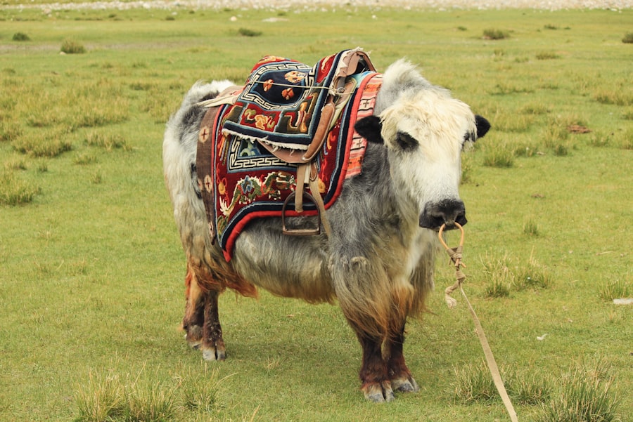
The plateau is home to a variety of plant and animal species specifically adapted to high altitudes, low temperatures, and arid conditions. This includes the yak, Tibetan antelope, snow leopard, and a diverse array of alpine vegetation. These species are integral to the ecological balance of the region. Their survival depends on the specific climatic conditions and the availability of water sources that sustain their habitat.
The Interdependence of Water and Ecosystems
The health of the plateau’s ecosystems is directly tied to its water resources. Rivers, lakes, and wetlands are vital habitats for many species. Changes in water flow, quality, or availability due to climate change can dramatically impact these habitats. For instance, reduced water levels in lakes can threaten migratory birds, while altered river flows can affect fish populations. It is a delicate dance between water and life, where a disruption in one can easily affect the other.
Threats to Local Livelihoods
The traditional livelihoods of many people living on the Tibetan Plateau are closely linked to the health of its ecosystems and the availability of water. Nomadic herding, for example, relies on the availability of pasturelands that are sustained by precipitation and meltwater. Degraded ecosystems and reduced water resources can lead to food insecurity and displacement for these communities. Their existence is a mirror reflecting the health of the land.
Conservation Efforts and Sustainable Management
Conservation efforts are crucial to protect the unique biodiversity of the Tibetan Plateau. This involves establishing protected areas, managing human activities to minimize environmental impact, and promoting sustainable resource use. Understanding the intricate relationship between water, ecosystems, and human populations is paramount for ensuring the long-term health of this vital region. Collaborative approaches involving local communities, scientists, and policymakers are essential for effective conservation.
FAQs
What is the Tibetan Plateau often referred to as the “Water Tower of Asia”?
The Tibetan Plateau is called the “Water Tower of Asia” because it is the source of many of Asia’s major rivers, including the Yangtze, Yellow, Mekong, and Brahmaputra. Its glaciers, snowfields, and high-altitude lakes store and release freshwater that sustains millions of people downstream.
Which major rivers originate from the Tibetan Plateau?
Several important rivers originate from the Tibetan Plateau, such as the Yangtze River, Yellow River, Mekong River, Indus River, Brahmaputra River, and Salween River. These rivers provide water for agriculture, drinking, and industry across multiple countries in Asia.
How does the Tibetan Plateau impact the climate and water cycle in Asia?
The Tibetan Plateau influences the Asian monsoon system and regional climate patterns by acting as a high-altitude heat source. Its glaciers and snowpack regulate seasonal water flow, releasing meltwater during warmer months that supports river systems and ecosystems downstream.
What environmental challenges threaten the Tibetan Plateau’s role as a water source?
Climate change is causing glaciers on the Tibetan Plateau to retreat, reducing the long-term availability of meltwater. Additionally, human activities such as mining, dam construction, and pollution pose risks to water quality and the natural hydrological cycle in the region.
Why is the Tibetan Plateau important for water security in Asia?
Because it feeds many of Asia’s largest rivers, the Tibetan Plateau is crucial for water security, agriculture, and livelihoods for over a billion people. Protecting its glaciers and ecosystems is essential to maintaining stable water supplies and preventing conflicts over shared water resources.