Understanding River Systems from Orbit: The Power of Satellite Remote Sensing
Rivers are the lifeblood of our planet, shaping landscapes, sustaining ecosystems, and providing essential resources for human civilization. Their dynamic nature, however, presents a significant challenge for comprehensive analysis. Traditional ground-based methods for monitoring river systems, while valuable, are often labor-intensive, spatially limited, and can be difficult to implement in remote or inaccessible areas. This is where satellite remote sensing emerges as a transformative technology. By providing a synoptic view of vast river basins and enabling continuous, repeated observations, satellite remote sensing offers unprecedented opportunities for understanding river hydrology at multiple scales. This article delves into the diverse applications of satellite remote sensing in analyzing river systems, highlighting its capabilities, limitations, and the future potential of this vital field.
Satellite remote sensing has become an invaluable tool in the field of river hydrology, providing critical data for monitoring water quality, flow patterns, and flood events. For a deeper understanding of how these technologies are applied in hydrological studies, you can explore a related article that discusses the integration of satellite imagery with ground-based observations to enhance river management practices. To read more about this topic, visit this article.
Fundamental Principles of Satellite Remote Sensing for Hydrology
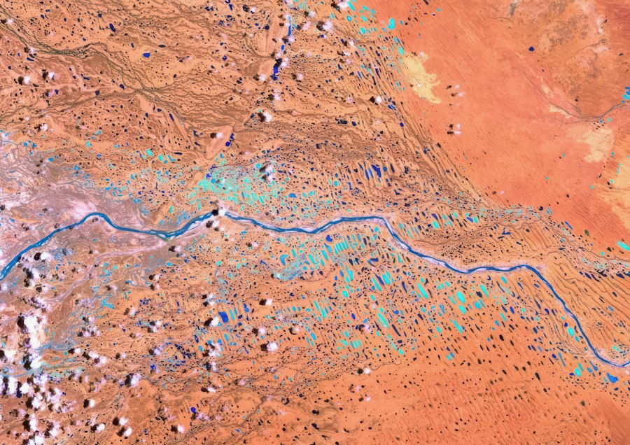
Satellite remote sensing involves the acquisition of information about the Earth’s surface from orbiting spacecraft. For hydrological applications, this typically involves instruments that detect and measure electromagnetic radiation reflected or emitted by the Earth. The type of sensor and the spectral bands it observes are crucial in determining the information that can be extracted.
Electromagnetic Spectrum and Sensor Types
The electromagnetic spectrum encompasses a wide range of wavelengths, from radio waves to gamma rays. Different hydrological variables interact with specific parts of this spectrum in distinct ways, allowing remote sensing instruments to differentiate them.
Visible and Near-Infrared (VNIR) Spectrum
Sensors operating in the VNIR spectrum are sensitive to the way water bodies reflect sunlight and how vegetation absorbs certain wavelengths. For instance, the spectral signature of clear water is relatively low in reflectance across these bands, while turbid water, containing suspended sediments, exhibits higher reflectance. Vegetation health, crucial for understanding watershed characteristics and evapotranspiration, can be assessed through indices like the Normalized Difference Vegetation Index (NDVI), which utilizes the strong chlorophyll absorption in the red spectrum and high reflectance in the near-infrared.
Shortwave Infrared (SWIR) Spectrum
The SWIR portion of the spectrum is particularly useful for detecting moisture content. Different wavelengths within SWIR are absorbed differently by water. This property allows for the estimation of soil moisture within river floodplains and the characterization of surface water extent, even in the presence of some atmospheric haze. Snow and ice also have distinct spectral properties in the SWIR, enabling their mapping and monitoring within river catchments.
Thermal Infrared (TIR) Spectrum
Thermal infrared sensors measure the Earth’s emitted radiation, which is directly related to surface temperature. This capability is vital for understanding evaporation rates from water surfaces and soil, as well as identifying thermal plumes in rivers, which can indicate the discharge of heated water from industrial sources or the influence of groundwater. Variations in surface temperature can also indirectly reveal moisture availability and land surface characteristics.
Microwave Spectrum (Passive and Active)
Microwave sensors, operating at longer wavelengths than VNIR and TIR, offer unique advantages, particularly their ability to penetrate clouds and provide information day or night. Passive microwave sensors measure naturally emitted microwave radiation, which is highly sensitive to the dielectric properties of water and ice. This allows for the estimation of soil moisture, snow water equivalent (SWE), and even surface water extent, especially in areas with persistent cloud cover. Active microwave sensors, such as Synthetic Aperture Radar (SAR), transmit their own microwave signal and measure the backscattered radiation. SAR is exceptionally useful for mapping surface water inundation, even under dense vegetation, due to its ability to detect the smooth surface of water, which causes specular reflection, resulting in low backscatter. SAR is also effective in monitoring changes in river morphology and the detection of floating ice.
Data Acquisition and Processing
Satellite remote sensing data is acquired by satellites in various orbits, including polar-orbiting and geostationary. Polar-orbiting satellites provide global coverage but have a lower temporal resolution for any given location, typically revisiting the same spot every few days. Geostationary satellites, positioned over a fixed point on the equator, offer very high temporal resolution, crucial for monitoring rapidly changing events like floods.
The raw data received from satellites undergoes extensive processing to convert it into usable hydrological information. This includes geometric correction to remove distortions caused by the satellite’s viewing angle and the Earth’s curvature, radiometric calibration to account for sensor variations and atmospheric effects, and atmospheric correction to remove the influence of the atmosphere on the measured radiation. Further processing involves feature extraction, classification, and the application of physical models to derive specific hydrological parameters.
Monitoring Surface Water Dynamics and Extent

One of the most direct and impactful applications of satellite remote sensing in river hydrology is the monitoring of surface water dynamics and extent. This includes mapping river channels, lakes, reservoirs, and crucially, flood inundation areas.
River Channel Mapping and Morphology
Satellites equipped with optical sensors can delineate river channels with high accuracy, especially during dry periods when the water extent is reduced. SAR imagery is particularly valuable for mapping river channels year-round and under varying atmospheric conditions. By analyzing time-series satellite data, researchers can track changes in river channel width, sinuosity, and the presence of meanders, oxbow lakes, and other geomorphological features. This information is vital for understanding river evolution, sediment transport, and the potential for channel migration. Understanding the changing morphology of a river is crucial for flood risk assessment, navigation, and ecological habitat assessment.
Flood Inundation Mapping and Early Warning
Flood inundation mapping is a critical application where satellite remote sensing has proven indispensable. During flood events, optical sensors can capture the extent of inundated areas by identifying the spectral signature of water. However, cloud cover can be a significant limitation. SAR sensors, with their all-weather capabilities, are ideally suited for mapping flood extents, even in regions prone to persistent cloudiness. By comparing pre-flood and during-flood imagery, inundation maps can be generated, providing vital information for emergency response, damage assessment, and the identification of vulnerable areas.
Furthermore, the frequent revisit times of some satellite constellations enable the near real-time monitoring of flood progression, contributing to improved flood forecasting and early warning systems. Analysis of historical flood inundation patterns derived from satellite data also aids in the development of probabilistic flood hazard maps, informing land-use planning and disaster preparedness. The integration of satellite-derived inundation data with hydrological models further enhances the accuracy and lead time of flood predictions.
Reservoir and Lake Level Monitoring
Satellite altimetry, using radar pulses to measure the precise distance between the satellite and the Earth’s surface, has revolutionized the monitoring of water levels in lakes and reservoirs. By tracking the height of the water surface over time, satellite altimetry provides crucial data for water resource management, including reservoir storage estimation, water allocation, and the assessment of drought conditions. Optical and SAR imagery also contribute by providing information on the surface area of these water bodies, which, when combined with level data, allows for more accurate volume calculations. This is particularly important for large inland seas and lakes where ground-based measurements are scarce.
Assessing Water Quantity and Quality Parameters
Beyond simply mapping water, satellite remote sensing offers powerful tools for quantifying water resources and assessing water quality within river systems and their catchments.
Estimation of Evapotranspiration and Water Balance
Evapotranspiration (ET) is a significant component of the water balance, representing the combined loss of water from a surface through evaporation and from plants through transpiration. Satellite remote sensing plays a crucial role in estimating ET at regional scales. Thermal infrared sensors are used to derive land surface temperature, which, along with other atmospheric variables obtained from meteorological satellites, can be used in energy balance models to estimate ET. Vegetation indices derived from VNIR and SWIR sensors are also used to assess vegetation cover and health, which are key drivers of transpiration.
By integrating ET estimates with precipitation data (also often derived from satellite observations), and streamflow data, hydrologists can develop comprehensive water balance studies for river basins. This is vital for understanding water availability, identifying areas of water stress, and managing water resources sustainably, especially in semi-arid and arid regions.
Soil Moisture Estimation
Soil moisture is a critical variable in hydrological processes, influencing infiltration, runoff, and evapotranspiration. Satellite-based passive microwave sensors have demonstrated significant capability in retrieving surface soil moisture content across large areas. The sensitivity of microwave radiation to the dielectric properties of water allows for the estimation of volumetric soil moisture. These measurements are invaluable for improving hydrological models, forecasting drought conditions, and optimizing agricultural water management within river catchments. The spatial and temporal coverage offered by microwave satellites allows for a more comprehensive understanding of soil moisture dynamics than ground-based networks alone.
Water Quality Parameter Monitoring
While challenging, satellite remote sensing can provide valuable insights into certain water quality parameters in rivers and associated water bodies. Optical sensors can detect the presence of suspended sediments, which are a key indicator of erosion and turbidity in rivers. By analyzing the spectral reflectance in specific bands, the concentration of total suspended solids (TSS) can be estimated. Chlorophyll-a concentration, an indicator of algal blooms and eutrophication, can also be monitored using optical sensors. Changes in water color, often associated with dissolved organic matter or pollution, can also be detected.
More advanced techniques involving hyperspectral sensors can potentially detect a wider range of constituents, including specific pollutants. While direct measurement of parameters like dissolved oxygen or nutrient concentrations is generally not possible from space, satellite-derived indicators can help identify areas requiring more detailed in-situ monitoring and assessment, thus guiding field sampling efforts.
Satellite remote sensing has become an invaluable tool in the field of river hydrology, providing critical data for understanding water dynamics and managing water resources effectively. For those interested in exploring this topic further, a related article can be found at MyGeoQuest, which discusses the latest advancements in satellite technologies and their applications in monitoring river systems. This resource highlights how remote sensing can enhance our ability to assess river health and predict flood events, ultimately contributing to better water management practices.
Understanding the Influence of Terrestrial Processes on River Systems
| Parameter | Satellite Sensor | Spatial Resolution | Temporal Resolution | Application in River Hydrology | Example Metric |
|---|---|---|---|---|---|
| Surface Water Extent | Landsat 8 OLI | 30 meters | 16 days | Mapping river width and floodplain extent | River width variation (meters) |
| Water Surface Elevation | Sentinel-3 SRAL | ~300 meters along track | 1-2 days | Monitoring river stage and flood forecasting | Water level change (cm) |
| River Discharge Estimation | MODIS | 250-500 meters | Daily | Estimating flow volume using surface area and velocity proxies | Discharge (m³/s) |
| Soil Moisture | SMAP | 9 km (L3 product) | 2-3 days | Assessing catchment wetness and runoff potential | Volumetric soil moisture (%) |
| Precipitation | GPM (Global Precipitation Measurement) | 0.1 degrees (~10 km) | 30 minutes | Input for hydrological models and flood prediction | Rainfall intensity (mm/hr) |
| River Surface Velocity | Sentinel-1 SAR | 10 meters | 6-12 days | Estimating flow velocity using radar backscatter changes | Velocity (m/s) |
River systems are intimately connected to the surrounding terrestrial environment. Satellite remote sensing allows for the comprehensive monitoring of land surface characteristics that directly influence river hydrology.
Land Cover and Land Use Change Detection
Changes in land cover and land use, such as deforestation, urbanization, and agricultural expansion, have profound impacts on river systems. Deforestation, for instance, can lead to increased soil erosion, higher runoff rates, and altered streamflow regimes. Urbanization can increase impervious surfaces, leading to flashier flood responses and increased pollutant loads. Satellite remote sensing, through the analysis of time-series imagery, is a powerful tool for detecting and quantifying these land cover and land use changes at various scales. By classifying images from different time points, changes can be identified, allowing for an assessment of their hydrological consequences. This information is crucial for sustainable land management practices and for developing mitigation strategies to address the impacts of land use change on rivers.
Snow Cover and Snow Water Equivalent (SWE) Monitoring
In mountainous regions, snowmelt is a primary source of water for many rivers. Satellite remote sensing is essential for monitoring snow cover extent and estimating Snow Water Equivalent (SWE), which represents the amount of liquid water contained within the snowpack. Optical sensors can accurately map snow-covered areas, while passive microwave sensors can provide estimates of SWE, even under cloudy conditions. These data are critical for forecasting snowmelt runoff, managing water resources during dry seasons, and assessing avalanche hazards. The temporal and spatial coverage of satellite data is particularly important in remote mountainous areas where ground-based snow measurements are scarce.
Vegetation Health and Biomass Estimation
The health and density of vegetation within a river basin significantly influence evapotranspiration, infiltration, and sediment transport. Satellite remote sensing provides tools to assess vegetation health through indices like NDVI. These indices can indicate stress in vegetation due to drought, disease, or pollution. Furthermore, satellite data can be used to estimate vegetation biomass, which is important for understanding carbon cycling and the potential for shading and root stabilization of riverbanks. Changes in vegetation cover can directly impact water quality through increased sediment load and altered water temperatures.
Challenges and Future Directions in Satellite Remote Sensing for River Hydrology
Despite the remarkable progress in satellite remote sensing for river hydrology, several challenges remain, and exciting future directions are emerging.
Data Integration and Model Coupling
One of the primary challenges is the effective integration of diverse satellite-derived data streams with existing hydrological models. Different sensors provide data at varying spatial and temporal resolutions, and with different inherent uncertainties. Developing robust methods for data assimilation and model coupling is crucial to fully exploit the potential of satellite observations for improving hydrological predictions and understanding. This includes the development of data fusion techniques that combine information from multiple sensors to create more comprehensive datasets.
Addressing Spatial and Temporal Resolution Limitations
While satellite technology is constantly improving, limitations in spatial and temporal resolution can still be a challenge for certain applications. For instance, accurately mapping small ephemeral streams or monitoring very rapid hydrological processes might still require finer resolution data than currently available from some operational satellite systems. The development of next-generation satellites with higher spatial and temporal resolutions, as well as constellations of small satellites, promises to address these limitations.
Improving Algorithm Accuracy and Uncertainty Assessment
The algorithms used to derive hydrological parameters from satellite data are continuously being refined. However, quantifying the uncertainties associated with these derived products remains an important area of research. Understanding and communicating these uncertainties is crucial for users to make informed decisions based on satellite-derived information. Continued validation of satellite products against in-situ measurements is essential for improving algorithm accuracy and building confidence in the data.
The Role of Machine Learning and Artificial Intelligence
The increasing volume and complexity of satellite data are driving the adoption of machine learning (ML) and artificial intelligence (AI) techniques. ML/AI can be used for advanced image classification, feature extraction, anomaly detection, and the development of more sophisticated predictive models. For instance, ML algorithms can be trained to identify subtle hydrological features in satellite imagery or to predict river flow based on a complex interplay of satellite-derived variables. The application of deep learning is showing particular promise in improving the accuracy of tasks like flood inundation mapping and soil moisture retrieval.
Towards Integrated Earth Observation Systems
The future of satellite remote sensing in river hydrology lies in the development of integrated Earth observation systems. This involves the seamless integration of data from various satellite platforms (optical, microwave, altimetry), coupled with ground-based observations, meteorological data, and advanced modeling frameworks. Such integrated systems will provide a holistic understanding of river systems, enabling more effective water resource management, flood risk assessment, and adaptation to climate change. The continued advancements in satellite technology, coupled with sophisticated data processing and analytical techniques, promise to further revolutionize our ability to understand and manage the world’s vital river systems. The synergy between remote sensing and advanced computational methods will undoubtedly unlock new frontiers in hydrological science and practice.

This River is Literally Erasing Islands
FAQs
What is satellite remote sensing?
Satellite remote sensing is the use of satellites to collect data about the Earth’s surface from a distance. This technology allows for the monitoring of various environmental parameters, such as land cover, vegetation health, and water quality.
How can satellite remote sensing be used for river hydrology?
Satellite remote sensing can be used for river hydrology by providing valuable information about river discharge, water levels, and flood extent. By analyzing satellite data, researchers can track changes in river flow over time and monitor the impact of human activities on river systems.
What are the advantages of using satellite remote sensing for river hydrology?
Some advantages of using satellite remote sensing for river hydrology include the ability to monitor large areas, access hard-to-reach locations, and collect data in near real-time. This technology also allows for cost-effective and efficient monitoring of river systems on a global scale.
Which satellite sensors are commonly used for river hydrology studies?
Commonly used satellite sensors for river hydrology studies include radar altimeters, which measure water levels, and optical sensors, which can provide information on water quality and sediment transport. Synthetic Aperture Radar (SAR) sensors are also used to monitor changes in river morphology.
What are some challenges associated with using satellite remote sensing for river hydrology?
Challenges associated with using satellite remote sensing for river hydrology include cloud cover, which can obstruct satellite imagery, and the need for ground validation to ensure the accuracy of remote sensing data. Additionally, the spatial and temporal resolution of satellite data may limit its applicability for certain hydrological studies.