
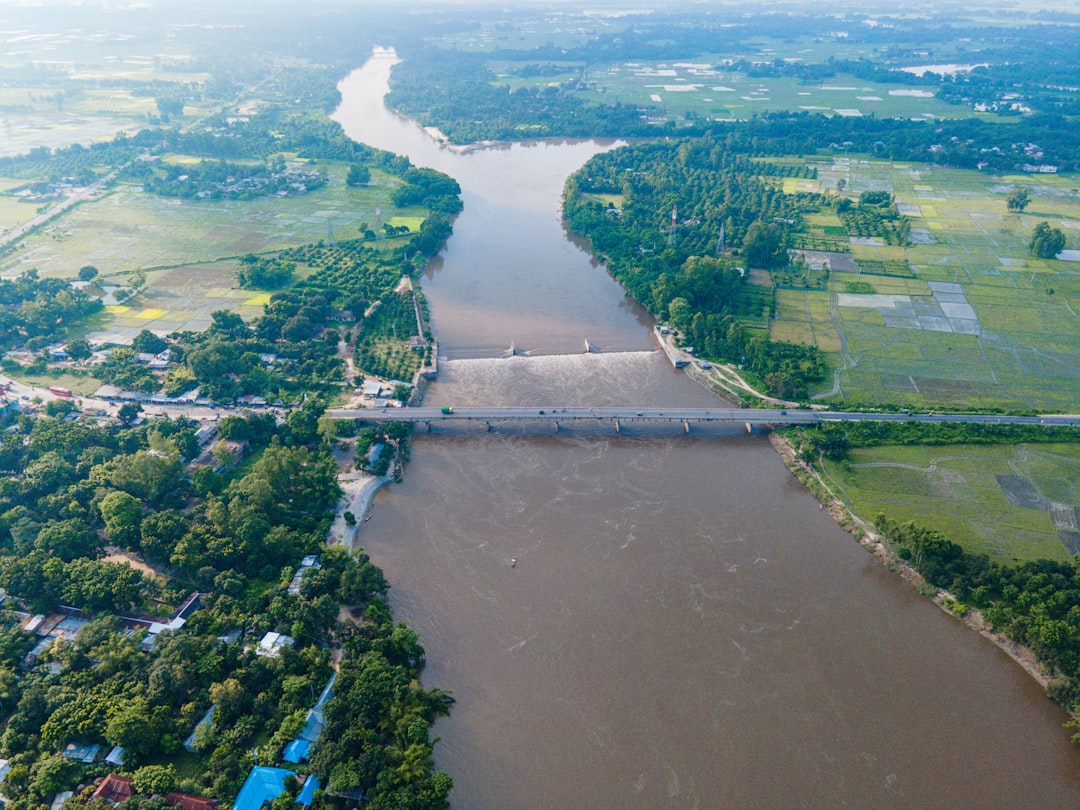
The Paraguay River, a serpentine artery vital to South American commerce, presents a unique set of challenges for navigation, particularly for the immense barges that ferry goods across its vast expanse. Understanding and adhering to barge draft limits is not merely a bureaucratic hurdle; it is the bedrock upon which efficient and safe riverine transportation is built. This article delves into the intricacies of navigating the Paraguay River, focusing specifically on the critical factor of barge draft limitations, to empower stakeholders with the knowledge needed to chart a successful course.
To effectively navigate the Paraguay River, one must first grasp the fundamental concept of barge draft.
What is Barge Draft?
The draft of a vessel, including a barge, refers to the vertical distance between the waterline and the lowest point of the hull. In simpler terms, it is the depth of the submerged portion of the barge. This measurement is crucial because it dictates the minimum water depth required for safe passage. A barge with a greater draft requires deeper water to operate without striking the riverbed, a scenario that can lead to damage, cargo loss, and costly delays.
Factors Influencing Draft
Several factors contribute to a barge’s draft, and a thorough understanding of these is essential for accurate calculation and management.
Load Weight and Distribution
The primary determinant of a barge’s draft is its cargo. As a barge is loaded, the weight of the cargo displaces a volume of water, causing the barge to sink lower. The distribution of this weight also plays a role; uneven loading can lead to uneven immersion and potential stability issues. Imagine a bucket of water; the more you fill it, the lower it sits in the water. Similarly, the heavier the cargo, the deeper the barge sits.
Hull Design and Freeboard
The inherent design of the barge’s hull, including its width, length, and shape, influences its buoyancy and how much weight it can carry before reaching a specific draft. Freeboard, the distance from the waterline to the upper edge of the deck, is also a critical consideration, as it represents the margin of safety against the ingress of water. A barge with a lower freeboard is more susceptible to taking on water in rough conditions.
Ballast Water
Barges often utilize ballast water to maintain stability or to adjust their draft when not fully loaded. Ballast tanks are filled with water when the barge is lighter, and emptied when it is loaded, allowing for precise control over the vessel’s trim and draft. This is akin to the counterweights used in construction cranes, providing balance and stability.
Consequences of Exceeding Draft Limits
The repercussions of exceeding the permissible draft limits on the Paraguay River can be severe and far-reaching.
Grounding and Damage
The most immediate and obvious consequence is grounding. If a barge’s draft exceeds the available water depth, its hull will come into contact with the riverbed. This can cause significant structural damage to the barge itself, potentially leading to hull breaches, leaks, and even sinking.
Cargo Loss and Contamination
When a barge grounds, the cargo within is at high risk. Commodities can be spilled into the river, polluting the environment and incurring substantial financial losses. Furthermore, if the barge takes on water, sensitive cargo can be contaminated or rendered unusable.
Navigation Obstructions and Delays
A grounded barge becomes a significant navigational hazard for other vessels. It can create bottlenecks, blocking passage and causing extensive delays for all traffic on the river. These delays translate directly into increased operational costs and missed market opportunities.
Environmental Impact
Environmental damage is another serious concern. Spills of cargo, fuel, or lubricants from a damaged barge can have devastating effects on aquatic ecosystems and surrounding habitats. Remediation efforts can be costly and protracted.
The Paraguay River has been facing significant challenges regarding barge draft limitations, which directly impact the transportation of goods and economic activities in the region. For a more in-depth analysis of the implications of these draft restrictions and their effects on trade, you can refer to the related article available at MyGeoQuest. This resource provides valuable insights into the current situation and potential solutions to enhance navigability along the river.
Paraguay River: A Navigational Landscape
The Paraguay River is not a uniform waterway; its characteristics fluctuate seasonally and geographically, directly impacting navigability and draft limitations.
Seasonal Variations in Water Levels
The ebb and flow of the Paraguay River’s water levels are dictated primarily by rainfall patterns, especially the monsoons in its upper reaches.
High Water Season (Crescente)
During the high water season, typically from late spring through summer, rainfall swells the river, increasing its depth and width. This period generally offers the most favorable conditions for navigation, allowing for deeper drafts and higher cargo capacities. The river transforms into a more forgiving and expansive highway.
Low Water Season (Seca)
Conversely, the dry season brings a significant decrease in water levels. This period poses the greatest challenge for navigation, as shallower channels and exposed sandbars become prevalent. Draft restrictions become paramount during these months, often forcing vessels to reduce their cargo loads. The river can appear as a more constricted and unforgiving path.
Geographical Features Influencing Draft
Beyond seasonal changes, the inherent geography of the Paraguay River presents unique navigational considerations.
Channel Depth and Width
The maintained depth and width of the navigable channel are continuously monitored and adjusted by river authorities. These parameters are not static; they are dynamic and subject to change based on dredging operations, siltation, and river flow. Understanding these variations is crucial for every captain.
Sandbars and Shoals
The formation of sandbars and shoals is a natural phenomenon in riverine environments. These submerged or partially submerged accumulations of sand and sediment can significantly reduce water depth in specific areas. Identifying and avoiding these obstacles is a constant undertaking for navigators. They act as hidden teeth in the riverbed.
Locks and Dams (Where Applicable)
While the majority of the Paraguay River’s navigation is unimpeded by locks and dams for a significant stretch, understanding any such infrastructure in upstream or downstream tributaries is vital for complete route planning. Their presence can introduce their own set of operational draft limitations and vessel handling requirements.
Establishing and Enforcing Draft Limits

The authorities responsible for the Paraguay River’s navigation play a crucial role in setting and enforcing the rules that govern barge draft.
Role of River Authorities
Organizations such as the Hidrovia Project coordination committees and national waterway authorities are tasked with ensuring the safe and efficient operation of the river.
Hydrographic Surveys and Data Collection
Regular and meticulous hydrographic surveys are the backbone of effective waterway management. These surveys map the riverbed, identify depths, and monitor changes in the navigable channel. This data forms the basis for all navigational advisements.
Navigational Channel Maintenance and Dredging
To combat siltation and maintain adequate depths, dredging operations are frequently undertaken. These are essential for keeping the “highway” of the river clear and accessible. Dredging is the ongoing work of sculpting and clearing the river’s path.
Publication of Navigational Notices and Advisories
River authorities issue regular navigational notices and advisories that communicate critical information to mariners. These include details on depths, channel conditions, temporary restrictions, and any unforeseen hazards. These advisories are the navigational compass for river captains.
Enforcement Mechanisms
Ensuring compliance with draft limits requires robust enforcement strategies.
Vessel Inspections and Audits
Regular inspections of vessels can verify compliance with draft regulations, cargo manifests, and safety equipment. These checks are vital to ensure that operators are adhering to the established rules.
Penalties for Non-Compliance
Penalties for exceeding draft limits can range from fines to more severe sanctions, including the detention of vessels. These measures are designed to deter non-compliance and uphold the safety standards of the waterway.
Calculating and Managing Barge Draft

Effective management of barge draft requires diligent calculation and strategic planning by vessel operators.
Pre-Voyage Planning and Load Calculation
Before any voyage commences, meticulous planning is essential to ensure that the barge’s draft remains within permissible limits.
Determining Maximum Allowable Draft
The maximum allowable draft for a specific segment of the Paraguay River will be dictated by the lowest point of the navigable channel and any specific restrictions published by the river authorities. This is the ceiling for how deep the barge can sit.
Accurate Cargo Weighing and Load Calculation
The weight of the cargo is the primary variable affecting draft. Accurate weighing of all cargo is paramount. Load calculators or software are often employed to precisely determine the draft based on the cargo weight, barge volume, and density of the water (which can vary slightly).
Considering Water Density
The density of water affects buoyancy. In freshwater, a barge will sit lower than in saltwater for the same weight. While the Paraguay River is primarily freshwater, variations in dissolved solids can slightly alter density, and this nuance is considered in precise load calculations.
Real-Time Monitoring and Adjustments
Draft management is not a static process; it requires ongoing monitoring and the ability to make adjustments during the voyage.
Use of Draft Marks and Gauges
Barges are equipped with draft marks painted on their hulls at the bow, stern, and midships. These allow the crew to visually read the draft at various points. Dedicated draft gauges can also provide more precise real-time measurements.
Communication with River Authorities
Maintaining open communication with river authorities is crucial. Any unexpected changes in river conditions or potential draft issues should be immediately reported.
Ballast Water Management Techniques
As mentioned earlier, ballast water is a key tool for adjusting draft and trim. Skilled use of ballast pumps allows for fine-tuning the barge’s immersion to stay within safe limits. This is the fine-tuning mechanism.
The Paraguay River has been facing significant challenges due to draft limitations for barge navigation, which affects the transportation of goods in the region. These restrictions can lead to increased shipping costs and delays, impacting trade and local economies. For a deeper understanding of the implications of these limitations, you can read a related article that explores the broader effects on regional commerce and infrastructure. This insightful piece can be found here.
Technological Innovations and Future Outlook
| Section of Paraguay River | Maximum Draft (meters) | Seasonal Variations | Navigation Restrictions | Comments |
|---|---|---|---|---|
| Port of Asunción to Concepción | 2.5 – 3.0 | Lower draft during dry season (May – October) | Reduced cargo load during low water periods | Critical for grain exports |
| Concepción to Bahía Negra | 2.0 – 2.5 | Significant draft reduction in dry months | Navigation limited to daylight hours | Shallow riverbed and sandbanks present |
| Bahía Negra to Puerto Busch | 1.8 – 2.2 | Draft can drop below 1.8 in extreme drought | Smaller barges preferred | Less commercial traffic |
| Overall River Average | 2.3 | Varies with rainfall and seasonal floods | Draft limitations impact barge size and cargo | Ongoing dredging projects to improve draft |
The navigation of the Paraguay River is continuously evolving, with technology playing an increasingly significant role in optimizing operations and enhancing safety.
Advancements in Hydrographic Surveying
Modern hydrographic survey equipment allows for more frequent, detailed, and accurate mapping of the riverbed.
Multi-beam Echosounders
These advanced sonar systems provide detailed cross-sections of the river channel, allowing for precise identification of depths and potential obstructions.
Autonomous Underwater Vehicles (AUVs)
The deployment of AUVs for surveying can cover large areas efficiently and access challenging or shallow regions, providing continuous data streams.
Digitalization of Navigational Data
The move towards digital platforms is revolutionizing how navigational information is accessed and utilized.
Electronic Chart Display and Information Systems (ECDIS)
ECDIS displays all relevant navigational information, including depth data, charting, and real-time advisories, directly on a ship’s bridge. This creates a dynamic and integrated navigational picture.
Real-time Data Integration and Predictive Analytics
Future developments will likely see greater integration of real-time data from various sources, coupled with predictive analytics. This could allow for forecasting of channel conditions and potential draft issues days or even weeks in advance. This offers a glimpse into the crystal ball of river navigation.
Sustainable Navigation Practices
Environmental considerations are increasingly influencing how river navigation is managed.
Improved Dredging Techniques
New dredging technologies aim to be more environmentally friendly, minimizing disruption to aquatic habitats.
Eco-friendly Cargo Handling and Spill Prevention
Strict protocols for cargo handling and advanced spill containment technologies are crucial for minimizing environmental impact.
In conclusion, successfully navigating the Paraguay River hinges on a profound understanding and meticulous management of barge draft limits. This requires a collaborative effort between river authorities, vessel operators, and a commitment to leveraging technological advancements. By viewing these limitations not as impediments but as essential guidelines for safe and efficient passage, the vital artery of the Paraguay River can continue to serve as a powerful engine of commerce and connectivity for the region.
WATCH NOW ▶️ SHOCKING: The $12 Trillion Lie Starving The World
FAQs
What is the typical draft limitation for barges on the Paraguay River?
The draft limitation for barges on the Paraguay River varies depending on the season and water levels but generally ranges between 2.5 to 3.5 meters during low water periods.
Why are draft limitations important for navigation on the Paraguay River?
Draft limitations are crucial to ensure safe navigation, prevent grounding, and protect the riverbed and infrastructure. They help determine the maximum cargo load a barge can carry without risking damage.
How do seasonal changes affect barge draft limitations on the Paraguay River?
Seasonal changes, especially during the dry season, lower water levels in the Paraguay River, reducing the allowable draft for barges. Conversely, during the rainy season, higher water levels permit deeper drafts and larger cargo loads.
Are there any regulations governing barge draft on the Paraguay River?
Yes, navigation authorities in Paraguay and neighboring countries enforce regulations that set maximum draft limits for barges to ensure safe and efficient river transport.
What measures can barge operators take to comply with draft limitations on the Paraguay River?
Operators can monitor water levels regularly, adjust cargo loads accordingly, use real-time navigation aids, and plan trips during favorable water conditions to comply with draft limitations.