
The Great Lakes, a network of interconnected freshwater bodies forming the largest such system on Earth, have recently exhibited unprecedented fluctuations in their water levels, marking both record highs and lows across different basins. These hydrological shifts are not merely statistical anomalies; they represent significant ecological, economic, and social challenges for the region and its diverse stakeholders. Understanding the multifaceted drivers behind these fluctuations, as well as their consequent impacts, is crucial for developing resilient adaptation strategies.
The water levels of the Great Lakes are governed by a complex interplay of natural processes and, increasingly, anthropogenic influences. This intricate hydrological system is a delicate balance, susceptible to variations in its primary inputs and outputs.
Precipitation Patterns
Precipitation, in the form of rain and snow, constitutes the primary input of water into the Great Lakes basin.
Rainfall Intensity and Frequency: Recent decades have witnessed a notable shift in precipitation patterns. While total annual precipitation averages may appear relatively stable, there has been an increase in the intensity of individual rainfall events. This phenomenon, often referred to as “rain bombs,” can lead to rapid runoff and localized flooding, contributing to rapid increases in lake levels. Conversely, extended periods of drought can significantly reduce inputs, acting as a downward pressure on water levels.
Snowfall Accumulation and Melt: The timing and magnitude of snow accumulation in the Great Lakes basin are critical. Heavy snowpacks, particularly when followed by warm spring temperatures, can lead to substantial runoff into the lakes. Conversely, milder winters with less snow or more gradual melts can diminish this spring flood pulse, impacting the seasonal peak of lake levels.
Evaporation Rates
Evaporation, the process by which water changes from a liquid to a gaseous state and rises into the atmosphere, represents a significant output from the Great Lakes.
Temperature Influence: Warmer air and water temperatures directly increase the rate of evaporation. As the Great Lakes region experiences warmer average temperatures, particularly during the open-water season, evaporation rates tend to climb. This can be a major factor in driving down lake levels, especially during periods of reduced precipitation or increased wind speeds.
Ice Cover Duration and Extent: The presence of ice cover on the lakes acts as a natural barrier to evaporation. When the lakes are covered in ice, evaporation is significantly reduced. Shorter ice cover durations or less extensive ice cover, often associated with warmer winters, allow for extended periods of open-water evaporation, contributing to water level declines.
Inflows and Outflows (Net Basin Supply)
The net basin supply (NBS) is a critical metric, representing the balance between precipitation, runoff, and evaporation within each lake’s sub-basin.
Inter-lake Connections and Regulation: The Great Lakes are interconnected, with water flowing from Lake Superior down through Lake Huron, Michigan, Erie, and finally to Lake Ontario before exiting into the St. Lawrence River. While some of these connections have regulatory structures, such as the dams on the St. Marys River (between Lakes Superior and Huron) and the Niagara River (between Lakes Erie and Ontario), these structures primarily manage outflows to mitigate extreme fluctuations, rather than control the underlying hydrological forces.
Groundwater Contributions: While less visible than surface runoff, groundwater flow also contributes to the lakes’ water balance. Changes in land use, such as increased impervious surfaces in urban areas, can alter groundwater recharge and discharge patterns, potentially impacting lake levels over longer timescales.
The fluctuating water levels of the Great Lakes have been a topic of significant concern, especially as they reach record highs and lows. For a deeper understanding of the implications of these changes on the environment and local economies, you can read a related article that explores the impact of these water level variations. Check it out here: Great Lakes Water Levels: Impacts and Insights.
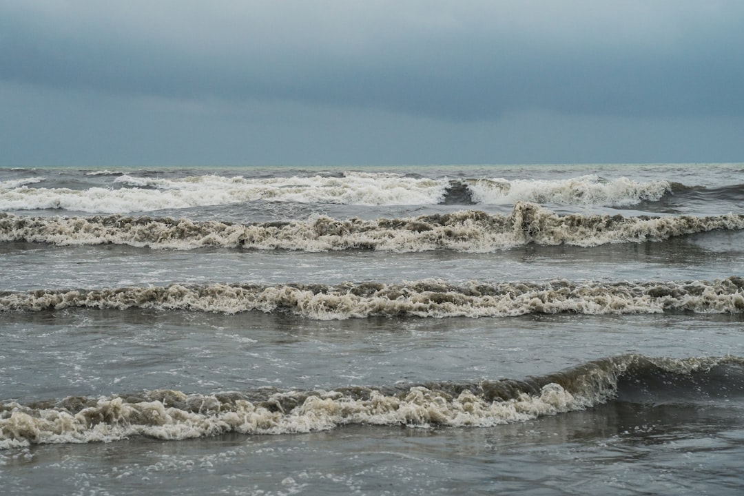
Record-Breaking Highs: The Deluge Continues
In recent years, several of the Great Lakes have experienced unprecedented high water levels, leading to widespread concerns about coastal erosion, infrastructure damage, and ecological disruption. These record highs represent a stark departure from the lower levels observed in earlier decades.
Impacts on Coastal Communities
The rising waters have presented complex challenges for communities situated along the Great Lakes shorelines.
Erosion and Property Damage: Higher lake levels exacerbate wave action, intensifying coastal erosion. Cliffs recede at accelerated rates, and beachfront properties are undermined, leading to significant financial losses for homeowners and municipalities. Residential structures, businesses, and recreational facilities become vulnerable to inundation and structural damage.
Infrastructure Strain: Critical infrastructure, including roads, wastewater treatment plants, and energy facilities, are often located near the shore. Elevated lake levels increase the risk of flooding for these assets, leading to costly repairs, service interruptions, and potential environmental hazards from overflowing sewage systems.
Ecological Consequences
The sudden and sustained high-water conditions have had a cascading effect on the delicate ecosystems of the Great Lakes.
Wetland Inundation: While wetlands are inherently adapted to fluctuating water levels, prolonged and excessively high water can stress certain plant species and alter habitat composition. For some species, this can be beneficial, expanding breeding grounds for specific fish or bird species. For others, it can lead to the loss of critical nesting or foraging areas.
Fish Spawning and Habitat Disruption: High water levels can impact fish spawning grounds, particularly for species that rely on specific depths and substrates. Increased turbidity from erosion can also reduce light penetration, affecting aquatic vegetation crucial for fish habitat and food sources.
Record Lows: The Shrinking Shores

Conversely, other periods and specific lakes have wrestled with historically low water levels, presenting a different set of challenges that highlight the volatile nature of the region’s hydrology.
Shipping and Navigation Difficulties
Lower water levels directly impact the vital shipping industry that relies on the Great Lakes.
Draft Restrictions: Deeper draft vessels, which transport bulk commodities like iron ore, grain, and coal, are forced to reduce their cargo loads to navigate shallower channels and ports safely. This “light loading” translates to fewer goods transported per trip, increasing freight costs and reducing the efficiency of the supply chain.
Dredging Requirements: Maintaining navigable depths in harbors and shipping channels necessitates frequent and costly dredging operations. Lower lake levels escalate the need for dredging, adding a significant financial burden to port authorities and the shipping industry.
Water Quality Concerns
Reduced water volumes can concentrate pollutants and alter water dynamics, impacting water quality.
Nutrient Concentration: With less water to dilute them, pollutants and nutrients from agricultural runoff and urban discharge become more concentrated, potentially exacerbating issues like harmful algal blooms. These blooms can deplete oxygen levels, creating “dead zones” that harm aquatic life and render water unsuitable for recreation or consumption.
Increased Turbidity: Lower water levels can increase the resuspension of sediments, leading to higher turbidity. This reduces light penetration, impacting photosynthesis by aquatic plants, and can also make water treatment more challenging and costly for municipal water suppliers.
Drivers of Change: A Confluence of Factors

The dramatic swings in Great Lakes water levels are not attributable to a single cause but rather to a complex interplay of natural variability and human-induced climate change.
Climate Change and its Fingerprints
Global climate change is increasingly recognized as a primary driver of the observed hydrological shifts in the Great Lakes.
Increased Temperature and Evaporation Rates: Warmer atmospheric and water temperatures, consistent with global warming trends, significantly enhance evaporation from the lake surfaces. This acts as a powerful mechanism for reducing water levels, especially during periods of open water.
Shifts in Precipitation Extremes: Climate models predict and observations confirm an increase in the frequency and intensity of extreme precipitation events. While total annual precipitation may not dramatically change, the episodic nature of these events – more rain falling in fewer, larger storms – can lead to rapid runoff and elevated lake levels, followed by periods of greater water loss through evaporation.
Reduced Ice Cover: Warmer winters lead to shorter durations and less extensive ice cover on the Great Lakes. As discussed earlier, ice acts as a blanket, suppressing evaporation. Reduced ice cover allows for extended periods of open-water evaporation, contributing to an overall net loss of water from the system.
Natural Variability and Oscillations
Beyond anthropocentric climate change, inherent natural cycles also contribute to the fluctuations.
El Niño-Southern Oscillation (ENSO): ENSO, a climate pattern in the Pacific Ocean, can influence weather patterns across North America, including the Great Lakes region. During El Niño events, the region tends to experience warmer and drier conditions, potentially leading to lower lake levels. La Niña, the opposite phase, is often associated with cooler and wetter conditions.
Great Lakes Hydroclimatic Cycles: The Great Lakes system itself exhibits natural oscillations in water levels, often over decadal timescales. These cycles are driven by long-term variations in regional weather patterns, including atmospheric pressure systems and wind directions, which affect precipitation, evaporation, and runoff.
Land Use Changes and Basin Management
Human activities within the Great Lakes basin also play a role, albeit generally a lesser one compared to climate and natural variability.
Urbanization and Impervious Surfaces: As urban areas expand, more land is converted into impervious surfaces (e.g., roads, parking lots, buildings). This prevents natural infiltration of rainwater into the ground, leading to increased surface runoff directly into the lakes and rivers. This can contribute to rapid rises in lake levels during heavy rainfall events.
Water Diversions (Limited Impact): While historical water diversions, such as the Chicago River reversal, have had localized impacts, their influence on the overall water balance of the Great Lakes is generally considered minor compared to climate drivers. International agreements strictly regulate any new or increased diversions.
Recent discussions about the Great Lakes have highlighted the record high and low water levels that have significant implications for the surrounding ecosystems and communities. For a deeper understanding of how these fluctuations impact local economies and environmental health, you can read a related article that explores these issues in detail. The article provides valuable insights into the causes and effects of these water level changes, making it a must-read for anyone interested in the future of the Great Lakes. To learn more, visit this informative article.
Adaptive Strategies and Future Outlook
| Great Lake | Record High Water Level (ft) | Year of Record High | Record Low Water Level (ft) | Year of Record Low |
|---|---|---|---|---|
| Lake Superior | 601.1 | 1986 | 596.3 | 1926 |
| Lake Michigan | 582.3 | 1986 | 576.2 | 1964 |
| Lake Huron | 581.5 | 1986 | 574.9 | 1964 |
| Lake Erie | 574.6 | 1986 | 569.0 | 1934 |
| Lake Ontario | 247.9 | 2019 | 243.3 | 1934 |
Addressing the challenges posed by extreme water level fluctuations requires a multi-faceted approach, encompassing scientific research, adaptive management, and regional collaboration. There is no single silver bullet, but rather a spectrum of protective measures and preventative actions.
Infrastructure Adaptations
Building resilience into coastal infrastructure is paramount in light of the new hydrological reality.
Shoreline Protection: Communities are exploring and implementing various shoreline protection measures. This includes “green infrastructure” solutions like restoring wetlands and creating natural buffers, which can absorb wave energy and reduce erosion. Hardened structures like seawalls and breakwaters are also utilized, though their ecological impacts are often a concern.
Elevated Structures and Flood-Proofing: For new construction in vulnerable areas, building codes are being updated to require elevated foundations and flood-resistant materials. Existing structures may also undergo retrofits to incorporate flood-proofing measures, such as relocating critical equipment to higher floors or installing backwater valves.
Ecosystem Restoration and Management
Protecting and restoring natural ecosystems can enhance the resilience of the Great Lakes and mitigate some of the impacts of extreme water levels.
Wetland Creation and Restoration: Wetlands act as natural sponges, absorbing excess water during high-water events and releasing it during dryer periods. Restoring degraded wetlands and creating new ones can help regulate water flows, filter pollutants, and provide crucial habitat.
Adaptive Habitat Management: Management practices need to become more dynamic, acknowledging the ever-changing nature of the lakes. This might involve identifying and protecting critical spawning grounds that are resilient to fluctuations, or adapting fishing regulations to account for changes in fish populations due to altered habitats.
Policy and Governance
Effective policy and strong governance mechanisms are essential for coordinating efforts across the basin.
International and Regional Collaboration: Given the transnational nature of the Great Lakes, sustained collaboration between the United States and Canada is critical. Joint commissions and agreements, such as the International Joint Commission (IJC) and the Great Lakes Compact, provide frameworks for managing shared waters and addressing common challenges.
Land Use Planning and Zoning: Municipalities need to revise land-use plans and zoning regulations to discourage development in highly vulnerable coastal areas. This includes establishing setback requirements, restricting construction in floodplains, and promoting compact, resilient development patterns.
Monitoring and Forecasting
Continuous monitoring and improved forecasting capabilities are vital tools for preparing for and responding to future fluctuations.
Advanced Hydrological Models: Scientists are developing and refining highly sophisticated hydrological and climate models to better predict future water level changes, both short-term and long-term. These models incorporate a vast array of data, from precipitation and temperature to ice cover and land use.
Early Warning Systems: Robust early warning systems, disseminating timely and accurate information on projected water levels, severe weather, and flood risks, are crucial for allowing communities and industries to take proactive measures, minimizing damage and ensuring public safety.
The Great Lakes, as a vital freshwater reservoir and economic engine, stand at a critical juncture. The recent oscillations between record high and low water levels serve as a powerful metaphor for the broader challenges presented by climate change. As readers, you are witnessing a dynamic system, a vast watery heart that beats with an increasingly erratic rhythm. The future of this magnificent ecosystem and the well-being of the communities it sustains hinge on our collective ability to understand these profound changes and to respond with proactive, adaptive, and collaborative strategies. The journey is ongoing, and the health of the Great Lakes depends on our vigilance and commitment.
SHOCKING: Why the Great Lakes Are Already Being Sold
FAQs
What are the Great Lakes?
The Great Lakes are a group of five large freshwater lakes in North America, consisting of Lake Superior, Lake Michigan, Lake Huron, Lake Erie, and Lake Ontario. They are the largest group of freshwater lakes by total area in the world.
What does it mean when the Great Lakes have record high or low water levels?
Record high or low water levels refer to the lakes reaching their highest or lowest measured water levels since record-keeping began. These levels can impact shipping, ecosystems, shoreline erosion, and local communities.
What factors contribute to changes in the Great Lakes water levels?
Water levels in the Great Lakes are influenced by precipitation, evaporation, runoff, and inflow/outflow patterns. Climate conditions such as droughts, heavy rainfall, and temperature changes also play significant roles.
How do record high water levels affect the Great Lakes region?
Record high water levels can lead to increased flooding, shoreline erosion, damage to infrastructure, and impacts on habitats. They may also affect recreational activities and commercial shipping operations.
What are the implications of record low water levels in the Great Lakes?
Record low water levels can expose shorelines, reduce water quality, hinder navigation and shipping, and negatively impact aquatic ecosystems. They may also affect water supply for communities and industries relying on the lakes.