The United States, a vast and diverse nation, is defined not only by its cultural and political landscapes but also by its geographic borders. These borders serve as the physical demarcations that separate the U.S. from its neighboring countries and oceans, shaping its identity and influencing its interactions with the world.
Stretching from the icy reaches of Alaska to the tropical shores of Hawaii, the geographic borders of the United States encompass a variety of terrains, climates, and ecosystems. This article delves into the various borders of the United States, exploring their significance and impact on trade, transportation, and national security. Understanding the geographic borders of the United States is essential for grasping the complexities of its relationships with neighboring countries and the world at large.
Each border presents unique challenges and opportunities that have shaped the nation’s history and development. From the bustling ports along the Atlantic and Pacific coasts to the rugged terrains shared with Canada and Mexico, these borders are not merely lines on a map; they are dynamic interfaces that facilitate cultural exchange, economic activity, and geopolitical strategy.
Key Takeaways
- The United States is bordered by the Atlantic Ocean to the east and the Pacific Ocean to the west.
- Canada forms the northern border of the United States, while Mexico forms the southern border.
- The border states on the east coast range from Maine to Florida, while on the west coast they range from California to Washington.
- Alaska and Hawaii are the border states that are not connected to the mainland United States.
- Geographic borders play a significant role in trade, transportation, and national security for the United States.
The Eastern Border: The Atlantic Ocean
The Atlantic Ocean forms the eastern boundary of the United States, stretching from the northern reaches of Maine down to the southern tip of Florida. This vast body of water has played a crucial role in shaping the nation’s history, serving as a gateway for exploration, trade, and immigration. The eastern coastline is dotted with major cities such as New York, Boston, and Miami, each of which has developed unique cultural identities influenced by their proximity to the ocean.
The Atlantic not only provides a means for maritime commerce but also serves as a recreational haven for millions of Americans who flock to its beaches each summer. The ocean’s influence extends beyond mere geography; it has been a catalyst for economic growth and international relations. The ports along the Atlantic coast are among the busiest in the world, facilitating trade with Europe, Africa, and beyond.
The shipping lanes that crisscross the Atlantic are vital arteries for goods ranging from automobiles to agricultural products. Furthermore, the ocean has historically been a conduit for cultural exchange, bringing diverse populations to American shores and enriching the nation’s social fabric.
The Western Border: The Pacific Ocean
To the west lies the Pacific Ocean, which serves as another significant geographic border for the United States. This expansive ocean stretches from California to Alaska, offering a contrasting landscape to that of the Atlantic. The Pacific coastline is characterized by rugged cliffs, sandy beaches, and bustling ports such as Los Angeles and San Francisco.
These cities have become vital centers for trade and tourism, drawing millions of visitors each year who seek to experience the natural beauty and cultural vibrancy of the West Coast. The Pacific Ocean also plays a critical role in international trade, particularly with countries in Asia. The shipping routes that traverse this ocean are among the busiest in the world, facilitating commerce between the U.S.
and major economies such as China, Japan, and South Korea. The economic ties forged through these maritime connections have significant implications for American industries, from technology to agriculture. Additionally, the Pacific serves as a strategic military frontier, with naval bases positioned along its shores to ensure national security and protect American interests in the region.
The Northern Border: Canada
| Year | Number of border crossings | Trade volume |
|---|---|---|
| 2015 | 103 million | 662 billion |
| 2016 | 105 million | 674 billion |
| 2017 | 108 million | 689 billion |
The northern border of the United States is defined by its long and peaceful boundary with Canada, stretching over 5,525 miles. This border is not only one of the longest international boundaries in the world but also one of the most amicable. The relationship between the U.S. and Canada is characterized by extensive trade partnerships, cultural exchanges, and collaborative efforts in various sectors such as environmental protection and security. The border is marked by numerous crossings that facilitate travel and commerce between the two nations. The economic impact of this border cannot be overstated. Canada is one of America’s largest trading partners, with billions of dollars in goods exchanged daily. The interconnectedness of supply chains means that industries on both sides of the border rely heavily on each other for resources and markets. Additionally, shared natural resources such as water bodies and forests necessitate cooperative management strategies to ensure sustainability and mutual benefit. This collaborative spirit has fostered a sense of camaraderie that transcends mere geography.
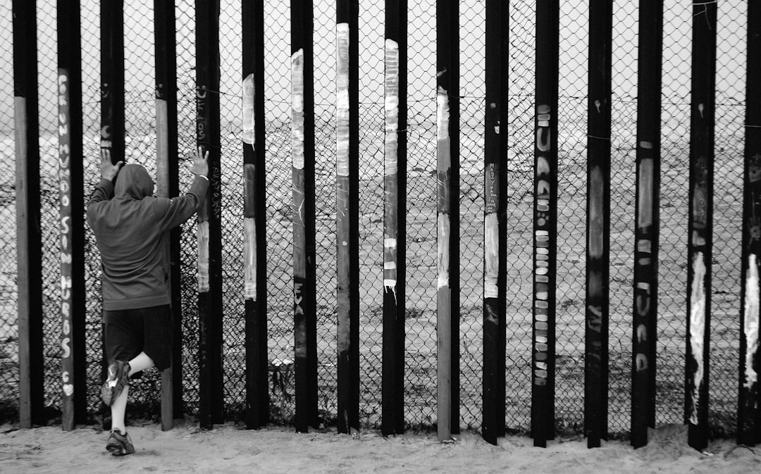
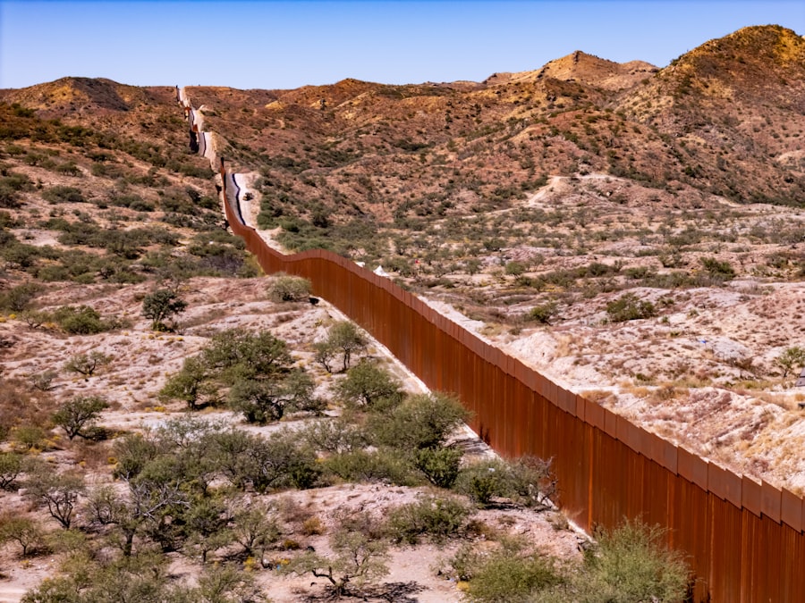
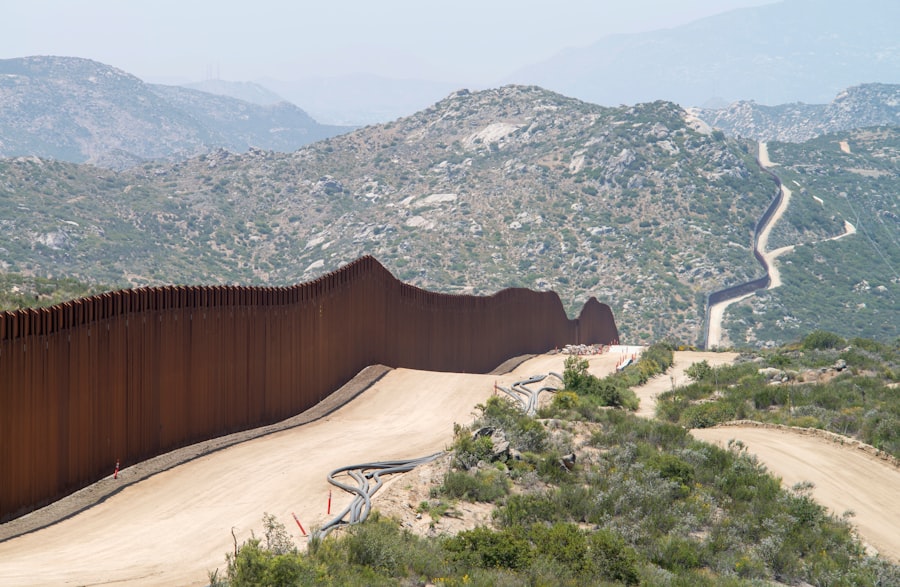
The Southern Border: Mexico
In contrast to its northern counterpart, the southern border with Mexico presents a more complex set of challenges and dynamics. Spanning approximately 1,954 miles, this border has been a focal point for discussions surrounding immigration policy, trade agreements, and national security. The relationship between the U.S. and Mexico is multifaceted; it encompasses economic cooperation through agreements like NAFTA (now USMCA) while also grappling with issues related to illegal immigration and drug trafficking.
While many individuals cross this border legally for work or family visits, others attempt to enter without authorization, leading to contentious debates over immigration reform. Despite these challenges, trade between the U.S. and Mexico remains robust, with millions of dollars in goods crossing the border daily. This economic interdependence highlights the importance of finding balanced solutions that address security concerns while promoting legitimate commerce.
The Border States: Maine to Florida
The states along the eastern border of the United States—from Maine down to Florida—exhibit a rich tapestry of cultural diversity influenced by their geographic proximity to both the Atlantic Ocean and international borders. Maine’s rugged coastline contrasts sharply with Florida’s sunny beaches, yet both states share commonalities in their reliance on tourism and maritime industries. Maine is known for its lobster fishing and picturesque lighthouses, while Florida attracts millions with its theme parks and warm climate.
As one moves southward along this eastern corridor, states like New York and Virginia emerge as economic powerhouses due to their strategic locations along major shipping routes. New York City serves as a global financial center while Virginia’s proximity to Washington D.makes it a hub for government-related activities. The cultural exchanges fostered by these states’ geographic positions contribute significantly to their identities, making them vibrant centers of activity that reflect both historical legacies and contemporary trends.
The Border States: California to Washington
On the western edge of the United States lies another set of border states stretching from California to Washington. These states are defined not only by their proximity to the Pacific Ocean but also by their diverse landscapes ranging from coastal cities to mountainous terrains. California stands out as a global leader in technology and entertainment, while Washington is known for its lush forests and thriving agricultural sector.
The economic interconnections among these states are profound; they share resources such as water from rivers that flow through multiple jurisdictions and engage in collaborative efforts to address environmental challenges like climate change. Additionally, cultural exchanges flourish along this corridor as people move freely between states for work or leisure. The Pacific Northwest’s unique blend of cultures—shaped by indigenous populations, immigrant communities, and urban centers—creates a dynamic social fabric that enriches American life.
The Border States: Alaska and Hawaii
Alaska and Hawaii represent two unique border states that are geographically separated from the contiguous United States yet play vital roles in defining national identity. Alaska’s vast wilderness is home to stunning landscapes ranging from towering mountains to expansive tundras. Its strategic location near Russia adds an element of geopolitical significance while also fostering rich indigenous cultures that have thrived for centuries.
Hawaii, on the other hand, is an archipelago known for its tropical climate and vibrant Polynesian heritage. As a popular tourist destination, Hawaii attracts millions seeking sun-soaked beaches and lush landscapes. Both states contribute significantly to America’s cultural diversity while also presenting unique challenges related to transportation and resource management due to their isolation from mainland markets.
The Impact of Geographic Borders on Trade and Transportation
Geographic borders significantly influence trade patterns and transportation networks within the United States. Each border presents distinct logistical challenges that shape how goods move across regions. For instance, ports along both coasts facilitate international shipping routes that connect American businesses with global markets.
The efficiency of these transportation networks is crucial for maintaining competitiveness in an increasingly interconnected world. Moreover, land borders with Canada and Mexico create additional layers of complexity regarding customs regulations and security measures. Trade agreements like USMCA have sought to streamline processes at these borders while addressing concerns related to labor standards and environmental protections.
As trade continues to evolve in response to global economic shifts, understanding how geographic borders impact transportation will remain essential for policymakers and businesses alike.
The Role of Geographic Borders in National Security
Geographic borders play a pivotal role in shaping national security strategies for the United States. The vast distances separating America from potential adversaries provide a natural buffer against direct military threats; however, they also necessitate vigilant monitoring of activities along land borders with Canada and Mexico. Issues such as drug trafficking, human smuggling, and terrorism require coordinated efforts between federal agencies to ensure public safety while respecting civil liberties.
Additionally, maritime security along both coasts remains paramount given their significance for trade routes and military operations.
As geopolitical dynamics continue to shift, adapting national security strategies in response to evolving threats will be crucial for protecting American sovereignty.
The Significance of the United States’ Geographical Borders
In conclusion, the geographic borders of the United States are far more than mere lines on a map; they are integral components that shape national identity, influence economic activity, and dictate security strategies. From the bustling ports along both coasts to the peaceful northern boundary with Canada and complex southern border with Mexico, each geographic feature contributes uniquely to America’s story. As globalization continues to reshape interactions among nations, understanding how these borders function will be essential for navigating future challenges while fostering cooperation across diverse communities.
Ultimately, recognizing the significance of geographic borders allows Americans to appreciate their place within a broader global context—one defined by shared challenges but also rich opportunities for collaboration and growth.
The real borders of the United States have been shaped by a complex history of treaties, conflicts, and negotiations. For a deeper understanding of how these borders were established and the implications they have today, you can read more in this related article: Understanding the Real Borders of the United States. This article provides insights into the geographical and political factors that have influenced the nation’s boundaries over time.
WATCH THIS! The Map You Trust Is A Lie: Why America Is Really 11 Rival Nations
FAQs
What are the real borders of the United States?
The real borders of the United States are defined by the boundaries established through treaties, agreements, and historical events. These borders include the land and maritime boundaries that the United States shares with its neighboring countries and territories.
What are the land borders of the United States?
The land borders of the United States include the borders with Canada to the north and Mexico to the south. These borders are defined by physical markers, such as border fences and monuments, and are regulated by border patrol agencies.
What are the maritime borders of the United States?
The maritime borders of the United States include the coastlines and territorial waters surrounding the country. These borders are defined by international law and agreements, and they extend from the coastline out to a distance of 12 nautical miles, where the country’s territorial sea ends.
Are there any disputed borders involving the United States?
Yes, there are several disputed borders involving the United States, including the maritime boundaries in the Arctic Ocean with Canada and Russia, as well as territorial disputes with neighboring countries and territories, such as the unresolved status of Puerto Rico.
How are the borders of the United States regulated and enforced?
The borders of the United States are regulated and enforced by various government agencies, including U.S. Customs and Border Protection, the U.S. Coast Guard, and other law enforcement agencies. These agencies are responsible for monitoring and controlling the flow of people, goods, and vessels across the borders.