Central Asia’s vast and rugged landscapes hold many wonders, and among its most striking geological formations are its extensive salt flats. These seemingly barren expanses, often shimmering under the relentless sun, are geological time capsules, offering a glimpse into the region’s ancient climatic history and unique ecosystems. Exploring these salt flats provides a profound encounter with the raw, unyielding beauty of nature and an appreciation for the resilience of life in extreme environments. This article delves into the geography, formation, ecological significance, and popular destinations within Central Asia’s stunning salt flats.
The formation of salt flats is a testament to the intricate dance of geology, hydrology, and climate over millennia. These vast, flat expanses of salt and other minerals are typically found in arid or semi-arid regions where evaporation rates significantly exceed precipitation. Understanding their origin is key to appreciating their unique character.
Tectonic Activity and Inland Seas
Central Asia’s geography is largely defined by its landlocked nature, a consequence of ancient tectonic collisions that uplifted massive mountain ranges, effectively trapping large bodies of water. The formation of extensive salt flats is often linked to the desiccation of these ancient inland seas. These seas, like the precursor to the Aral Sea, would have contained dissolved salts and minerals leached from surrounding rocks over millions of years.
The Evaporative Process
As the climate in these regions became progressively drier, the water from these ancient lakes and seas began to evaporate. The water molecules, energized by the sun’s heat, transitioned into vapor and ascended into the atmosphere, leaving behind the dissolved salts and minerals. This process, repeated over eons, concentrated these dissolved solids, eventually leading to the formation of the crystalline crusts that characterize salt flats. Imagine a vast petri dish where water slowly disappears, leaving behind the dissolved contents.
Sedimentation and Mineral Deposits
Beyond simple evaporation, the geological history of the land plays a crucial role. Sediments carried by rivers and wind would have accumulated within these ancient basins. As the water receded, these sediments, along with the salts, formed distinct layers. Different mineral compositions, dependent on the source rocks and the specific hydrological conditions, contribute to the varied colors and textures seen in different salt flats. Gypsum, halite (common table salt), and various sulfates and carbonates are commonly found, creating a palette of whites, grays, and even subtle pinks and yellows.
Wind and Water Erosion
Once formed, salt flats are not static. Wind, a powerful sculptor in arid landscapes, constantly reshapes the surface, creating ripples and drifts of salt crystals. While precipitation is scarce, rare but intense rainfall events can temporarily inundate the flats, smoothing their surfaces and depositing new layers of sediment and minerals. This cyclical interaction between wind and infrequent water contributes to the ever-evolving topography of these remarkable environments.
Salt flats, also known as salt pans or salt deserts, are fascinating geographical features found in various regions, including Central Asia. These expansive, flat areas are formed through the evaporation of water, leaving behind a crust of salt and other minerals. A related article that delves deeper into the geography of salt flats in Central Asia can be found at this link: Explore the Unique Geography of Central Asia’s Salt Flats. This article provides insights into the formation, ecological significance, and cultural aspects of these remarkable landscapes.
The Aral Sea Catastrophe: A Stark Example
The plight of the Aral Sea stands as one of the most tragic man-made environmental disasters of the 20th century and provides a stark, albeit human-instigated, illustration of salt flat formation on an accelerated and devastating scale. Its desiccation has transformed vast swathes of its former bed into a new, toxic salt desert.
Diversion of Rivers and Agricultural Demands
Historically, the Aral Sea was the world’s fourth-largest lake, fed by the Amu Darya and Syr Darya rivers. Beginning in the mid-20th century, extensive irrigation projects were initiated to support cotton cultivation in the arid Central Asian republics. The ambition was to turn desert into arable land, but this came at the cost of the lifeblood of the Aral Sea.
Environmental Repercussions and Salinization
The diversion of these vital rivers dramatically reduced the inflow of freshwater into the Aral Sea. As a consequence, the lake began to shrink at an alarming rate. The remaining water became increasingly saline, rendering it uninhabitable for fish and other aquatic life. The exposed seabed, once a vibrant ecosystem, transformed into a massive salt and dust bowl.
The Emergence of a Toxic Salt Desert
The exposed Aral Sea bed is now a vast expanse of salt flats, often referred to as the Aralkum Desert. The salt crusts here are not only laden with sodium chloride but also with agricultural chemicals, pesticides, and fertilizers that were washed into the rivers and subsequently concentrated as the water evaporated. This makes the Aralkum a hazardous environment, with toxic dust storms posing significant health risks to surrounding populations. Exploring this area requires caution and an understanding of its perilous nature, serving as a poignant reminder of the delicate balance between human endeavor and environmental sustainability.
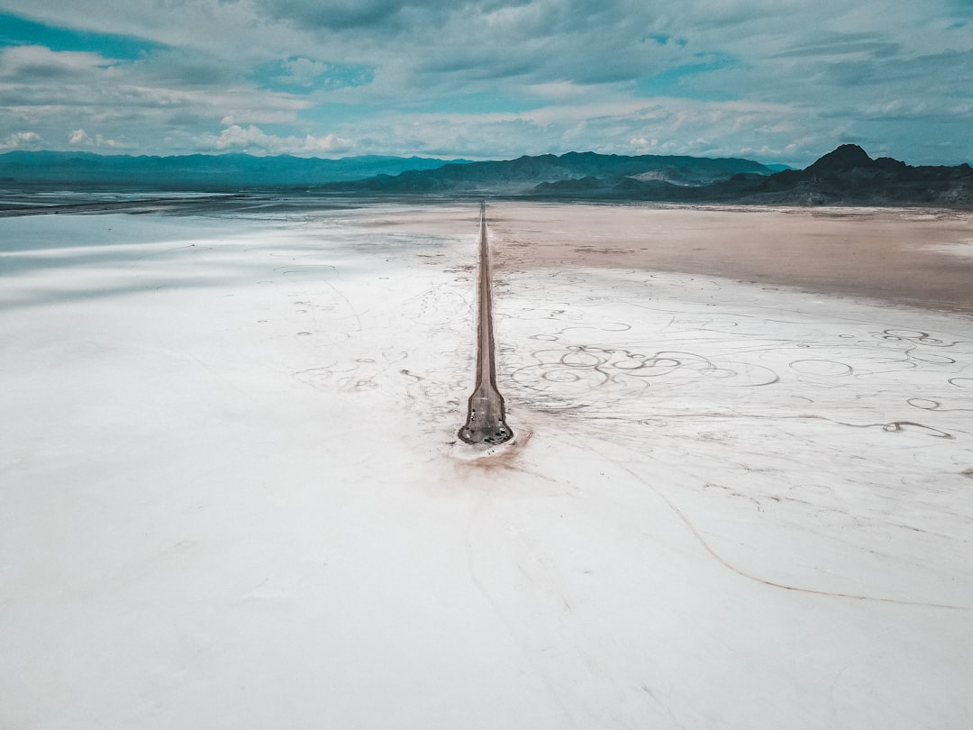
Iconic Salt Flats of Central Asia
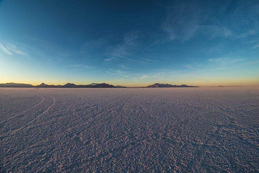
Central Asia is home to several large and visually captivating salt flats, each with its own unique characteristics and appeal. These destinations offer a raw and unforgettable experience for those willing to venture off the beaten path.
Turkmenistan’s Darvaza Crater (Door to Hell)
While not a traditional salt flat in the sense of a dried lakebed, the Darvaza Gas Crater in Turkmenistan is an anomaly that deserves mention due to its proximity and its otherworldly appearance, often found amidst saline landscapes.
Formation and Ignition
The Darvaza crater, colloquially known as the “Door to Hell,” is a geyser of natural gas that has been burning continuously since the 1970s. The origin story varies, but the most widely accepted account attributes its formation to a Soviet natural gas drilling accident. The ground collapsed, creating a large crater filled with natural gas. To prevent the spread of poisonous gases, geologists decided to ignite the gas, believing it would burn out within a few weeks. This prognostication proved incorrect, and the fiery pit continues to burn.
Visual Spectacle and Tourism
The imagery of a crater spewing flames under the vast desert sky is both terrifying and mesmerizing. During the day, it appears as a gaping maw in the earth; by night, the inferno illuminates the surrounding landscape with an eerie glow. While safety protocols are in place, the sight is a powerful symbol of the earth’s raw energy and the potential consequences of human interaction with its resources. The surrounding desert often exhibits salt formations, highlighting the arid environment in which this unique phenomenon exists.
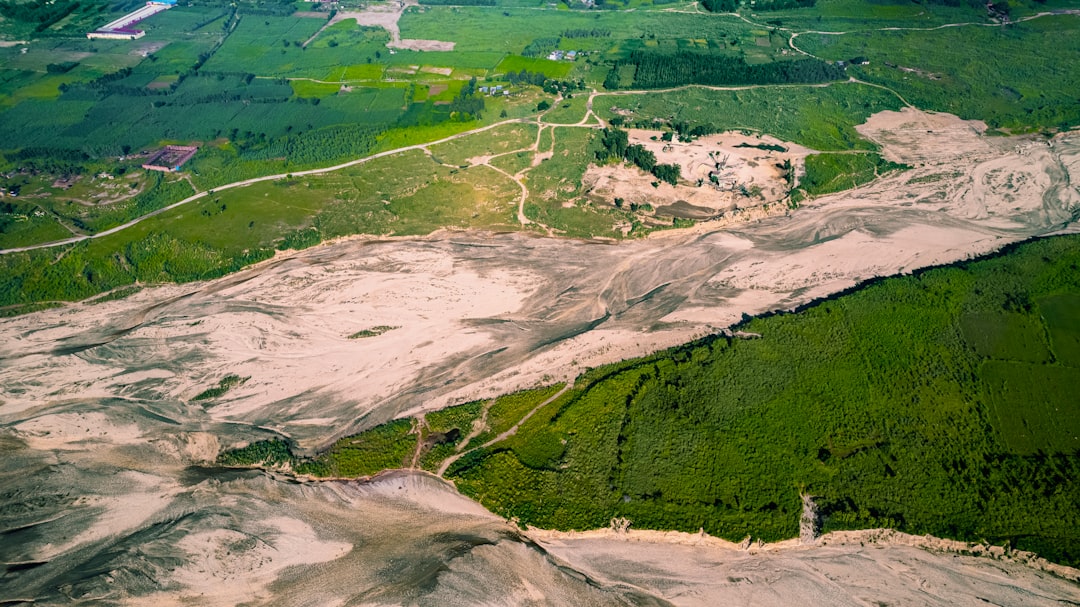
Uzbekistan’s Aydarkul Lake and Kyzylkum Desert
Uzbekistan boasts the Aydarkul Lake, a man-made reservoir that has expanded significantly, creating a vast saline water body and surrounding salt marshes that resemble natural salt flats, especially in its drier fringes. This region is part of the immense Kyzylkum Desert, a landscape dominated by sand and salt.
Lake Formation and Ecological Significance
Aydarkul Lake was formed as a result of Soviet-era water management projects, primarily intended for irrigation runoff. Over time, the lake has grown, creating a unique ecosystem in the heart of the Kyzylkum Desert. The lake supports a surprising diversity of birdlife, including migratory species, and has become an important water source for local communities and wildlife.
Desert Landscapes and Nomadic Life
The Kyzylkum Desert, meaning “Red Sands,” is the second-largest desert in Central Asia. Its landscape is characterized by vast expanses of sand dunes, gravel plains, and, crucially for this discussion, salt marshes and playas. These salt flats, often shimmering expanses of white, are a common feature of the desert’s topography. For centuries, nomadic peoples have traversed these lands, their lives intrinsically linked to the rhythms of the desert and its limited water sources. Exploring this region offers a glimpse into traditional ways of life that have adapted to the harsh yet beautiful environment.
Kazakhstan’s Koksengir Salt Lake
Located in the western part of Kazakhstan, Koksengir Salt Lake is a significant natural salt formation, showcasing the raw power of evaporation in a continental climate.
Unique Mineral Composition
Koksengir is known for its high concentration of various salts and minerals, leading to distinct water colors and crust formations. The surrounding area reflects the typical arid environment of the region, with sparse vegetation and a vast, open sky. The lake’s salinity can fluctuate depending on seasonal rainfall and evaporation rates.
A Remote Wilderness Experience
Accessing Koksengir can be challenging, and it remains a relatively untouristed destination. This remoteness contributes to its pristine natural state, offering an authentic wilderness experience for those seeking solitude and an encounter with untouched landscapes. The silence, broken only by the wind and the calls of distant birds, contributes to the profound sense of isolation and natural grandeur.
Flora and Fauna: Life in the Saline Environment

Despite their apparent barrenness, salt flats are not devoid of life. Specialized flora and fauna have evolved remarkable adaptations to survive in these extreme conditions, demonstrating the tenacity of nature.
Halophytes: Salt-Tolerant Plants
The plant life found on and around salt flats is known as halophytes – plants that can tolerate saline conditions. These species have developed a range of strategies to cope with high salt concentrations in the soil and water.
Physiological Adaptations
Some halophytes excrete excess salt through specialized glands on their leaves. Others accumulate salt within their vacuoles, preventing it from interfering with their cellular processes. Another strategy involves diluting the salt internally by taking up water. Common examples include various species of succulents, grasses, and shrubs that can withstand the challenging salinity.
Ecological Role
These salt-tolerant plants form the base of the food web in these arid ecosystems. They provide sustenance and shelter for various invertebrates and smaller animals, creating microhabitats within the seemingly uniform expanse of the salt flat. Their presence, though sparse, is crucial for the functioning of these unique environments.
Resilient Wildlife in Arid Zones
The animal life of salt flats is equally specialized, consisting of species that have adapted to the scarcity of water and the harsh conditions.
Insects and Arachnids
Invertebrates such as specialized insects and arachnids are often abundant on salt flats. These creatures can withstand high temperatures and low moisture levels. Many have developed life cycles that are timed with the infrequent rains, emerging to feed and reproduce during these brief periods of relative abundance.
Avian Life and Migratory Birds
Salt lakes and their surrounding areas, even those with high salinity, can be crucial stopover points for migratory birds. The shallow waters and the invertebrates that inhabit them provide vital feeding grounds. Bird species such as flamingos, stilts, and various waterfowl can be observed in these areas during migration periods, a testament to the resilience of these ecosystems in supporting transient life.
Mammals Adapted to Aridity
Certain mammals, such as gazelles, wild asses, and various rodent species, have also adapted to life in arid and saline environments. They often possess specialized kidneys to conserve water and obtain moisture from the plants they consume. Their ability to traverse vast distances in search of food and water is essential for their survival in these challenging landscapes.
The unique geography of Central Asia is highlighted by its stunning salt flats, which are not only fascinating natural formations but also play a significant role in the region’s ecology and economy. For those interested in exploring this topic further, a related article can be found at My Geo Quest, where you can learn more about the diverse landscapes and environmental significance of these salt flats. These expansive areas offer insights into the climatic conditions and geological processes that shape Central Asia’s distinctive terrain.
Exploring Central Asia’s Salt Flats: Practical Considerations
| Salt Flat Name | Location | Area (sq km) | Elevation (m) | Type | Notable Features |
|---|---|---|---|---|---|
| Ustyurt Plateau | Kazakhstan / Uzbekistan | 200,000 | 150-300 | Salt flat and desert plateau | Extensive salt crust, karst formations |
| Aral Sea Desert (Aralkum) | Uzbekistan / Kazakhstan | ~5,000 (former seabed) | 40-60 | Salt flat / dried lake bed | Exposed salt flats due to sea shrinkage |
| Chott El Djerid (near Central Asia border) | Near Central Asia (North Africa) | 7,000 | -10 to -20 | Salt flat | Seasonal salt crust, large playa |
| Betpak-Dala Desert Salt Flats | Kazakhstan | ~50,000 | 300-400 | Salt flat and desert | Salt pans and seasonal lakes |
| Kyzylkum Desert Salt Flats | Uzbekistan / Kazakhstan / Turkmenistan | ~300,000 | 200-300 | Salt flat and desert | Large arid salt flats with sparse vegetation |
Embarking on an exploration of Central Asia’s salt flats requires careful planning and an awareness of the unique challenges associated with these remote and often extreme environments. Respect for the fragile ecosystems and the local cultures is paramount.
Best Times to Visit and Travel Logistics
The optimal time to visit Central Asia’s salt flats generally falls during the cooler spring and autumn months. Summer can be exceptionally hot, with temperatures soaring to dangerous levels, making exploration difficult and potentially hazardous. Winter, while offering dramatic icy landscapes, can also bring harsh winds and challenging travel conditions.
Transportation and Accessibility
Accessibility to many salt flats can be limited, often requiring specialized off-road vehicles. Some are located in remote desert regions, far from major transportation hubs. Domestic flights may connect to regional centers, followed by overland travel by jeep or hire car. It is advisable to arrange tours with experienced local guides who are knowledgeable about the terrain, weather conditions, and logistical requirements.
Accommodation and Supplies
Accommodation options in the vicinity of salt flats can be basic, ranging from nomadic yurt stays to guesthouses in small towns. Camping is also an option for the more adventurous. It is essential to carry ample supplies of food, water, and fuel, as services are scarce in these remote areas.
Essential Gear and Safety Precautions
Proper gear is crucial for a safe and enjoyable exploration of the salt flats. The arid and saline environment demands specific considerations.
Clothing and Sun Protection
Lightweight, breathable clothing that covers the body is recommended to protect against the sun’s intense rays. Wide-brimmed hats, sunglasses, and high-SPF sunscreen are essential. Due to the reflective nature of salt, experiencing sun glare is significant.
Footwear and Water
Sturdy, closed-toe footwear is necessary to protect feet from sharp salt crystals and uneven terrain. Comfortable, broken-in hiking boots are ideal. Carrying a substantial amount of potable water is non-negotiable. Dehydration can set in rapidly in hot, dry conditions.
Navigation and Communication
Given the vast, featureless nature of salt flats, reliable navigation tools such as GPS devices and physical maps are indispensable. Mobile phone reception can be non-existent in many areas, so informing someone of your itinerary and expected return time is a critical safety measure. Carrying a satellite phone or personal locator beacon can provide an essential lifeline in emergency situations.
Respecting the Environment and Local Cultures
The natural beauty of salt flats is intertwined with the cultural heritage of the regions they inhabit. Visitors have a responsibility to minimize their impact.
Leave No Trace Principles
Adhering to “Leave No Trace” principles is crucial. This means packing out all trash, avoiding damage to vegetation, and respecting the natural formations. The salt crusts are delicate and can be easily damaged, so avoid walking on fragile areas unnecessarily.
Cultural Sensitivity
Interacting with local communities requires respect for their customs and traditions. It is advisable to learn a few basic phrases in the local language and to be mindful of dress codes when visiting villages or religious sites. Understanding and appreciating the nomadic lifestyles and their connection to the land will enrich the travel experience.
Conclusion: Unveiling the Stark Beauty
Central Asia’s salt flats are not merely geological curiosities but profound landscapes that tell stories of geological time, climatic shifts, and the extraordinary resilience of life. From the fiery spectacle of Darvaza to the expansive saline deserts surrounding the remnants of the Aral Sea, these environments offer a stark yet captivating beauty that is both humbling and awe-inspiring. Exploring these regions provides a unique opportunity to connect with a raw, untamed Earth, reminding us of the power of nature and the importance of preserving these extraordinary natural wonders for generations to come. The silence, the vastness, and the shimmering expanses of salt create an experience that lingers long after the journey ends, a testament to the enduring allure of Central Asia’s magnificent salt flats.
▶️ STOP: The Middle Corridor Is A Death Trap
FAQs
What are salt flats and how do they form in Central Asia?
Salt flats, also known as salt pans or salt deserts, are flat expanses of ground covered with salt and other minerals. In Central Asia, they typically form in endorheic basins where water from rivers or rainfall evaporates, leaving behind salt deposits. These areas often have high evaporation rates and limited drainage.
Where are the major salt flats located in Central Asia?
Major salt flats in Central Asia include the Aral Sea basin salt flats, the Ustyurt Plateau between Kazakhstan and Uzbekistan, and parts of the Turan Depression in Turkmenistan. These regions are characterized by extensive salt crusts resulting from the evaporation of ancient lakes and seas.
What is the climate like in the salt flat regions of Central Asia?
The climate in Central Asia’s salt flat regions is typically arid or semi-arid, with hot summers and cold winters. Precipitation is low, and evaporation rates are high, which contributes to the formation and maintenance of salt flats.
Are salt flats in Central Asia important for any economic activities?
Yes, salt flats in Central Asia are important for the extraction of minerals such as salt, potash, and sometimes lithium. These minerals are used in various industries including agriculture, chemical production, and manufacturing.
How do salt flats affect the local ecosystem and environment in Central Asia?
Salt flats create unique ecosystems that support specialized plant and animal species adapted to high salinity and harsh conditions. However, they can also be fragile environments sensitive to climate change and human activities such as mining and water diversion.