
The Drake Passage, a body of water located between the southern tip of South America and Antarctica, is renowned for its tumultuous seas and unpredictable weather patterns. This narrow stretch of ocean, measuring approximately 800 kilometers (500 miles) wide, serves as a critical maritime route for vessels traveling to and from the Antarctic region. Named after the English explorer Sir Francis Drake, who navigated these waters in the late 16th century, the passage has since become infamous among sailors and researchers alike for its challenging conditions.
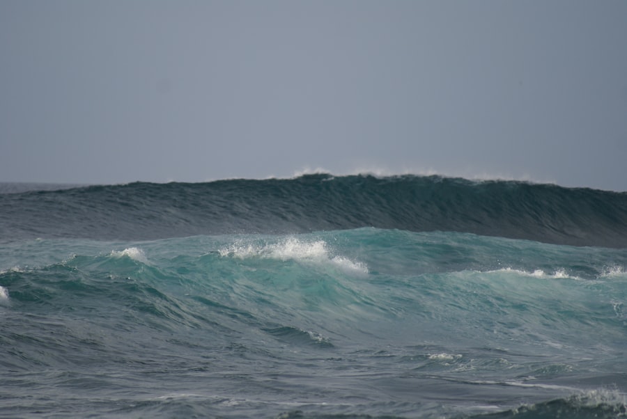
The confluence of the Atlantic and Pacific Oceans creates a unique environment where strong currents and fierce winds converge, resulting in some of the highest waves on the planet. Navigating the Drake Passage is not merely a test of seamanship; it is a complex interplay of environmental factors that can significantly impact a vessel’s journey. The passage is characterized by its rough seas, which can change rapidly, making it essential for mariners to possess a thorough understanding of wave dynamics and weather patterns.
As more expeditions venture into this remote area for scientific research, tourism, and commercial shipping, the importance of safe navigation through the Drake Passage has never been more critical. Understanding the intricacies of wave height and its implications for navigation is vital for ensuring the safety of vessels traversing this formidable stretch of ocean.
Key Takeaways
- The Drake Passage is a treacherous stretch of water between South America’s Cape Horn and the South Shetland Islands of Antarctica.
- Understanding wave height is crucial for navigating the Southern Ocean, as it directly impacts ship stability and safety.
- Wave height in the Drake Passage can reach extreme levels, posing significant challenges for ship navigation and safety.
- Current technology allows for the measurement and prediction of wave height in the Southern Ocean, aiding in safe navigation.
- Factors such as wind speed, ocean currents, and seafloor topography can affect wave height in the Drake Passage, making navigation even more challenging.
Understanding Wave Height and its Importance for Navigating the Southern Ocean
Wave height is a fundamental aspect of oceanography that refers to the vertical distance between the crest of a wave and its trough. In the context of the Southern Ocean, where the Drake Passage is located, wave height can vary dramatically due to a multitude of factors, including wind speed, ocean currents, and atmospheric pressure systems. Mariners must pay close attention to wave height as it directly influences a vessel’s stability, maneuverability, and overall safety during transit.
High waves can pose significant risks, leading to capsizing or structural damage to ships, particularly those that are not designed for such extreme conditions. The significance of understanding wave height extends beyond immediate safety concerns; it also plays a crucial role in voyage planning and operational efficiency. Accurate predictions of wave height allow ship captains to make informed decisions regarding their routes and speed, potentially avoiding areas with particularly hazardous conditions.
This knowledge is especially pertinent in the Drake Passage, where conditions can shift rapidly and unexpectedly. By comprehensively understanding wave dynamics, mariners can enhance their navigational strategies, ensuring not only their safety but also the successful completion of their voyages.
The Impact of Wave Height on Ship Navigation in the Drake Passage

The impact of wave height on ship navigation in the Drake Passage cannot be overstated. High waves can create treacherous conditions that challenge even the most experienced sailors. When waves reach heights of several meters, they can cause vessels to pitch and roll violently, leading to discomfort for passengers and crew alike.
In extreme cases, these conditions can result in loss of cargo or even capsizing. Therefore, understanding wave height is essential for ensuring that ships are adequately equipped to handle such challenges. Moreover, wave height influences navigation strategies significantly.
For instance, vessels may need to adjust their speed or alter their course to minimize exposure to high waves. This can lead to longer travel times and increased fuel consumption, impacting operational costs. Additionally, high waves can hinder communication systems and navigation equipment, further complicating the situation for mariners.
As such, a comprehensive understanding of wave height is crucial for effective navigation in the Drake Passage, allowing crews to anticipate challenges and respond accordingly.
Current Technology for Measuring and Predicting Wave Height in the Southern Ocean
| Technology | Advantages | Disadvantages |
|---|---|---|
| Buoy Systems | Accurate measurements, real-time data | Expensive to deploy and maintain |
| Radar Systems | Non-contact measurement, wide coverage | Interference from weather conditions |
| Satellite Altimetry | Global coverage, remote sensing | Limited spatial resolution |
| Wave Gliders | Autonomous, long-duration deployment | Limited payload capacity |
Advancements in technology have revolutionized the way wave height is measured and predicted in the Southern Ocean. Modern tools such as satellite altimetry, buoys equipped with wave sensors, and advanced meteorological models provide invaluable data for mariners navigating the Drake Passage. Satellite altimetry utilizes radar signals to measure sea surface heights over vast areas, offering real-time information about wave conditions across the ocean.
This technology allows for comprehensive monitoring of wave patterns and trends, enabling sailors to make informed decisions based on accurate data. In addition to satellite technology, buoys deployed throughout the Southern Ocean play a critical role in measuring wave height. These buoys are equipped with sensors that continuously collect data on wave characteristics, including height, period, and direction.
This information is transmitted back to shore-based facilities where it is analyzed and disseminated to mariners in real-time. Furthermore, meteorological models that incorporate atmospheric data help predict wave height based on prevailing weather conditions. By leveraging these technological advancements, sailors can navigate the Drake Passage with greater confidence and safety.
Factors Affecting Wave Height in the Drake Passage
Several factors contribute to the variability of wave height in the Drake Passage, making it a unique maritime environment. One primary factor is wind speed; strong winds can generate larger waves by transferring energy to the water surface. In this region, prevailing westerly winds often create formidable swells that can reach impressive heights.
Additionally, ocean currents play a significant role in shaping wave patterns; when opposing currents collide with wind-driven waves, they can amplify wave height and create chaotic sea conditions. Another critical factor affecting wave height is atmospheric pressure systems. Low-pressure systems can lead to increased wind speeds and turbulent seas, while high-pressure systems typically result in calmer conditions.
The interaction between these systems can create rapidly changing weather patterns that mariners must navigate carefully. Understanding these factors is essential for predicting wave height accurately and ensuring safe passage through the Drake Passage.
Historical Incidents and Challenges of Navigating the Drake Passage
The history of navigation through the Drake Passage is marked by numerous incidents that highlight its challenges. One notable event occurred in 1914 when Ernest Shackleton’s ill-fated expedition aboard the Endurance faced treacherous conditions while attempting to cross this notorious stretch of water. The ship became trapped in pack ice, ultimately leading to a harrowing survival story that has since become legendary in maritime history.
Such incidents underscore the unpredictable nature of the Drake Passage and serve as cautionary tales for modern mariners. In addition to historical incidents involving famous expeditions, countless commercial vessels have encountered difficulties while navigating these waters. Reports of ships experiencing severe weather conditions or structural damage due to high waves are not uncommon.
These challenges emphasize the importance of thorough preparation and understanding of wave dynamics when planning voyages through the Drake Passage. As maritime traffic continues to increase in this region due to tourism and research activities, learning from past incidents becomes crucial for ensuring safe navigation.
Importance of Accurate Wave Height Information for Safe Passage
Accurate wave height information is paramount for ensuring safe passage through the Drake Passage. Mariners rely on this data not only for immediate safety but also for effective voyage planning. Knowing current and predicted wave heights allows captains to make informed decisions about their routes and speeds, potentially avoiding areas with hazardous conditions.
This proactive approach can significantly reduce risks associated with navigating rough seas. Furthermore, accurate wave height information contributes to overall operational efficiency. By optimizing routes based on real-time data, vessels can minimize fuel consumption and reduce travel times.
This is particularly important in an era where environmental sustainability is becoming increasingly prioritized within the maritime industry. As such, investing in reliable sources of wave height information is essential for both safety and efficiency when traversing the challenging waters of the Drake Passage.
The Role of Wave Height Maps in Navigating the Southern Ocean
Wave height maps serve as invaluable tools for mariners navigating the Southern Ocean, particularly in the Drake Passage. These maps provide visual representations of current and predicted wave heights across vast areas of ocean, allowing sailors to assess conditions at a glance. By utilizing these maps, captains can identify regions with potentially dangerous waves and adjust their routes accordingly.
In addition to enhancing situational awareness, wave height maps facilitate better communication among crew members and between vessels operating in close proximity. When all parties have access to consistent data regarding wave conditions, they can coordinate their actions more effectively, reducing risks associated with navigating rough seas. As technology continues to advance, these maps are becoming increasingly sophisticated, incorporating real-time data from various sources to provide mariners with up-to-date information essential for safe navigation.
Strategies for Navigating the Drake Passage in High Wave Conditions
Navigating the Drake Passage during high wave conditions requires careful planning and execution of specific strategies aimed at minimizing risks. One common approach involves altering a vessel’s course to approach waves at an angle rather than head-on; this technique helps reduce the impact of waves on the ship’s hull and enhances stability during transit. Additionally, adjusting speed can also play a crucial role; slower speeds may allow vessels to ride over waves more effectively while reducing stress on both crew and equipment.
Another strategy involves thorough pre-voyage preparation that includes reviewing weather forecasts and wave predictions extensively before departure. By understanding expected conditions along their route, mariners can make informed decisions about whether to proceed or delay their journey until conditions improve. Furthermore, maintaining open lines of communication with other vessels operating in the area allows crews to share information about changing conditions or potential hazards encountered during transit.
Future Developments in Wave Height Monitoring and Prediction for the Southern Ocean
As technology continues to evolve rapidly, future developments in wave height monitoring and prediction for the Southern Ocean hold great promise for enhancing maritime safety in challenging environments like the Drake Passage. Innovations such as artificial intelligence (AI) and machine learning algorithms are being integrated into meteorological models to improve accuracy in predicting wave heights based on historical data patterns combined with real-time observations. Additionally, advancements in sensor technology are enabling more precise measurements of wave characteristics across various scales—from local buoys providing detailed data near shorelines to satellite systems offering broader coverage over vast ocean areas.
These developments will not only enhance situational awareness for mariners but also contribute significantly to scientific research aimed at understanding climate change impacts on ocean dynamics.
Navigating the Drake Passage Safely and Efficiently
Navigating the Drake Passage presents unique challenges that require careful consideration of various factors influencing wave height and sea conditions. As maritime traffic increases in this region due to tourism and research activities, understanding how these elements interact becomes increasingly vital for ensuring safe passage through these treacherous waters. Accurate wave height information plays a crucial role in voyage planning while advanced technologies continue to enhance monitoring capabilities.
By employing effective strategies tailored specifically for high-wave conditions—such as adjusting course angles or speeds—mariners can mitigate risks associated with navigating this formidable stretch of ocean successfully. As future developments unfold within monitoring technologies alongside improved predictive models emerge over time; it is clear that navigating safely through one of Earth’s most challenging maritime environments will remain an ongoing pursuit requiring vigilance from all who dare traverse its depths.
Today, the Drake Passage is experiencing significant wave activity, with wave heights reaching impressive levels. For those interested in understanding more about the current conditions and the factors influencing these wave patterns, a related article provides in-depth insights. You can explore this topic further by visiting this article on MyGeoQuest, which offers a comprehensive analysis of the Drake Passage’s wave dynamics and their implications for maritime navigation and safety.
WATCH NOW! Drake Passage: Earth’s Deadliest Waters Revealed
FAQs
What is the Drake Passage?
The Drake Passage is the body of water between the southern tip of South America and the northern tip of the Antarctic Peninsula. It is known for its rough seas and challenging sailing conditions.
What is wave height?
Wave height is the vertical distance between the crest and the trough of a wave. It is a measure of the size of waves in a body of water.
How is wave height measured?
Wave height is typically measured by instruments such as buoys, wave rider buoys, or wave buoys. These instruments use sensors to measure the height of passing waves.
What is the significance of wave height in the Drake Passage?
The wave height in the Drake Passage is significant because of the strong winds and currents in the area, which can lead to very large and powerful waves. This makes the passage one of the most challenging and dangerous areas for maritime travel.
Is there a map showing wave height in the Drake Passage today?
Yes, there are various sources and organizations that provide real-time or near real-time maps showing wave height in the Drake Passage. These maps are often used by sailors, researchers, and organizations involved in maritime operations.