
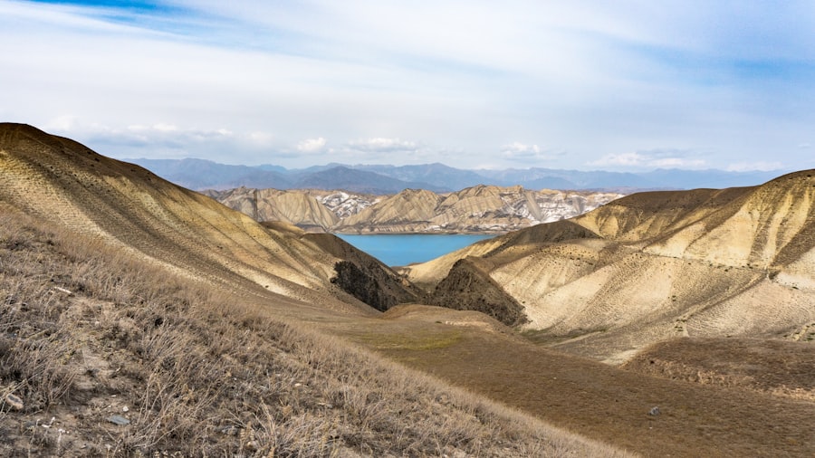
The Toktogul Reservoir, a colossal artificial lake located in the Tien Shan mountains of Kyrgyzstan, serves as a vital artery for the nation, irrigating agricultural lands, generating hydroelectric power, and providing a significant proportion of the country’s freshwater supply. Its operational health is intrinsically linked to the economic stability and environmental well-being of Kyrgyzstan and downstream nations. Consequently, the meticulous monitoring of its water levels transcends mere hydrological measurement; it becomes a critical exercise in national security, resource management, and regional diplomatic stability. This article delves into the multifaceted aspects of monitoring Toktogul’s water levels, exploring the methodologies, challenges, and implications of this essential task.
The Toktogul Reservoir is more than just a body of water; it is a linchpin of Kyrgyzstan’s socio-economic fabric. Its immense volume, approximately 19.5 cubic kilometers at full capacity, acts as a hydrological buffer, regulating the flow of the Naryn River and, subsequently, the Syr Darya, one of Central Asia’s two major rivers. Understanding this fundamental role is the prerequisite to appreciating the intensity of effort dedicated to its oversight.
Agricultural Backbone
The agricultural sector in Kyrgyzstan, employing a substantial portion of the workforce, is heavily reliant on irrigation. The water released from Toktogul during critical growing seasons directly determines crop yields, particularly for cotton, wheat, and fruit. A deficit in water levels can translate into parched fields, crop failures, and devastating economic consequences for rural communities. Conversely, excessive rainfall and subsequent releases can lead to inundation, destroying infrastructure and livelihoods.
Powering the Nation
The Toktogul Hydroelectric Power Plant (HPP), situated at the dam, is the largest power station in Kyrgyzstan. It contributes a significant share of the country’s electricity generation, playing a pivotal role in ensuring energy independence and meeting industrial and domestic demands. The height of the water column in the reservoir directly impacts the head available for the turbines, thus dictating the plant’s power output. Fluctuations in water levels, therefore, have direct implications for national energy security, influencing decisions on energy imports and exports.
Regional Interdependence
The waters originating from Toktogul eventually flow into Kazakhstan, Tajikistan, and Uzbekistan, countries that also depend heavily on the Syr Darya for irrigation and other uses. This shared resource creates a complex web of regional interdependencies and potential for geopolitical friction. Monitoring Toktogul’s water levels, therefore, is not solely an internal Kyrgyz affair but a matter of regional concern, frequently featuring in bilateral and multilateral discussions. The reservoir acts as a colossal tap, and its opening and closing are watched with keen interest by downstream neighbors.
Recent discussions about the Toktogul reservoir water levels have highlighted the critical importance of water management in Central Asia. For a deeper understanding of the regional implications and the challenges faced, you can refer to a related article that explores the hydrological dynamics and socio-economic impacts in the area. For more information, visit this article.
Methodologies for Water Level Assessment
The monitoring of Toktogul’s water levels utilizes a combination of traditional and cutting-edge technologies, each offering unique advantages in data acquisition and analysis. This multi-pronged approach ensures robustness and accuracy in what is an inherently dynamic system.
In-Situ Measurements
The foundational layer of data collection involves direct, on-site measurements. This traditional method, though labor-intensive, provides invaluable ground truth for more advanced techniques.
Manual Gauging Stations
Throughout the reservoir’s perimeter and at strategic points along the Naryn River, manual gauging stations are maintained. These involve staff gauges, which are essentially large rulers, read by trained personnel at regular intervals. These readings provide a direct visual representation of the water surface elevation. While straightforward, this method is susceptible to human error and limited by accessibility, especially during harsh weather conditions.
Automated Pressure Transducers
More modern in-situ approaches include automated pressure transducers. These devices are submerged in the water and measure the hydrostatic pressure, which is directly proportional to the depth of the water column above them. Data from these transducers is often transmitted in real-time via satellite or cellular networks to central monitoring stations, offering continuous updates without requiring constant human intervention.
Remote Sensing Techniques
Remote sensing has revolutionized water level monitoring, offering a broad, synoptic view that traditional methods cannot provide. Satellites orbiting the Earth have become vital eyes in the sky.
Satellite Altimetry
Satellite altimetry involves satellites equipped with radar altimeters that emit microwave pulses towards the Earth’s surface. By measuring the time it takes for these pulses to return, and knowing the satellite’s precise orbital position, the distance from the satellite to the water surface can be calculated. This yields highly accurate measurements of the absolute water surface elevation. Missions like일에 대한 TOPEX/Poseidon, Jason series, and Sentinel-3 have been instrumental in providing consistent, long-term data sets for large water bodies like Toktogul. The advantage of this method lies in its ability to monitor inaccessible areas and provide consistent data regardless of weather conditions.
Synthetic Aperture Radar (SAR)
SAR systems, often employed on satellites, can penetrate clouds and operate effectively day and night, making them particularly useful in regions with persistent cloud cover. While not directly measuring water levels in the same way as altimeters, SAR imagery can delineate the extent of the water body with high precision. By combining SAR data with digital elevation models (DEMs), changes in water volume can be inferred, providing another layer of valuable information. The changing shoreline, like a tide mark on a beach, provides an indirect but crucial indicator of volume dynamics.
Optical Satellite Imagery
High-resolution optical satellite imagery, from missions such as Landsat and Sentinel-2, provides visual documentation of the reservoir’s surface area. By analyzing the extent of the water body over time, particularly in conjunction with bathymetric data (the underwater equivalent of topography), changes in water volume can be estimated. While optical imagery is constrained by cloud cover, it offers a visually intuitive representation of the reservoir’s state.
Challenges in Accurate Monitoring
Despite the sophistication of modern monitoring techniques, several significant challenges persist in ensuring consistently accurate and reliable data for Toktogul’s water levels. These obstacles are both environmental and logistical, demanding continuous innovation and adaptation.
Topographical Complexity
The rugged, mountainous terrain surrounding Toktogul presents inherent difficulties. Steep slopes, deep canyons, and variable shoreline geometries can complicate ground-based measurements and introduce errors in remote sensing interpretations, particularly when estimating surface area from satellite imagery. Accurately mapping the complex bathymetry of the reservoir, a prerequisite for accurate volume calculations, remains an ongoing challenge.
Climatic Extremes
The Tien Shan region experiences dramatic temperature fluctuations, from scorching summers to frigid winters. During winter months, large portions of the reservoir can freeze, altering the surface characteristics and potentially interfering with satellite altimetry signals. Extreme weather events, such as heavy snowfall or torrential rains, can also disrupt ground-based infrastructure and make manual access challenging. These climatic swings are like a restless patient, constantly shifting, demanding vigilance.
Sedimentation
Over time, rivers carry sediment into reservoirs, which settles at the bottom, reducing the reservoir’s storage capacity. This process, known as sedimentation, subtly alters the relationship between water level and actual volume. Without periodic, detailed bathymetric surveys, the accuracy of volume estimates based solely on water level measurements can degrade over time. The reservoir is slowly silting up, a silent, relentless process that complicates long-term management.
Data Integration and Verification
Integrating data from diverse sources – manual gauges, automated sensors, and various satellite platforms – requires robust data management systems and sophisticated algorithms. Discrepancies between different datasets need to be identified, reconciled, and understood. The “ground truth” provided by in-situ measurements is essential for validating remote sensing data, but this validation process itself can be labor-intensive and require significant expertise.
The Role of Data in Decision-Making
The primary purpose of monitoring Toktogul’s water levels is to inform critical decision-making processes across multiple sectors. The data collected acts as the raw material for strategic planning, operational adjustments, and policy formulation.
Hydroelectric Power Generation Scheduling
Operators of the Toktogul HPP rely heavily on water level forecasts to optimize power generation schedules. Decisions on turbine operation, water release, and overall energy output are directly influenced by the anticipated inflow into the reservoir and the scheduled water demands downstream. Maintaining an optimal water level is a delicate balancing act, akin to a skilled juggler keeping multiple balls in the air, ensuring enough water for power now, and enough for irrigation later.
Irrigation Management
Agricultural authorities utilize water level data to plan irrigation schedules for various crops. Timely and accurate information allows for the efficient allocation of water resources, minimizing waste and ensuring that sufficient water is available during critical growth stages. This is particularly crucial in years of drought when every drop of water becomes a precious commodity.
Flood Control and Risk Mitigation
During periods of heavy precipitation or rapid snowmelt, high water levels can pose a risk of overflow and downstream flooding. Monitoring efforts enable authorities to proactively release water in a controlled manner, mitigating the risk of catastrophic floods. Conversely, in anticipation of droughts, the conservation of water within the reservoir becomes paramount. The reservoir acts as a colossal sponge, absorbing excess and releasing reluctantly during scarcity.
Regional Water Diplomacy
Given the transboundary nature of the Syr Darya River basin, water level data from Toktogul plays a crucial role in regional water diplomacy. This information is shared with downstream countries to facilitate coordinated water management plans, preventing disputes and fostering cooperation. Transparency in data sharing is a cornerstone of trust and stability in the region.
The Toktogul reservoir, a crucial water source for Kyrgyzstan, has been experiencing fluctuating water levels that significantly impact agricultural practices and energy production in the region. Recent discussions around the management of this reservoir highlight the importance of sustainable water usage and the need for effective policies to address these challenges. For more insights on this topic, you can read a related article that delves into the implications of the changing water levels at this link.
Future Outlook and Technological Advancements
| Date | Water Level (meters) | Storage Volume (million cubic meters) | Inflow (cubic meters/second) | Outflow (cubic meters/second) | |
|---|---|---|---|---|---|
| 2024-01-01 | 900.5 | 18,500 | 120 | 100 | Normal levels |
| 2024-02-01 | 902.0 | 18,750 | 130 | 110 | Stable inflow |
| 2024-03-01 | 899.0 | 18,300 | 115 | 120 | Increased outflow |
| 2024-04-01 | 895.5 | 17,800 | 100 | 130 | Drawdown for maintenance |
| 2024-05-01 | 897.0 | 18,000 | 110 | 115 | Recovery phase |
The field of hydrological monitoring is continuously evolving, with exciting technological advancements promising even greater accuracy, efficiency, and accessibility in monitoring Toktogul’s water levels. The horizon promises even sharper eyes and swifter hands in managing this vital resource.
Enhanced Satellite Capabilities
Future satellite missions are expected to offer improved spatial and temporal resolution for altimetry and imagery, providing more frequent and detailed observations. Advances in synthetic aperture radar interferometry (InSAR) could offer new ways to monitor subtle changes in reservoir bathymetry and dam deformation, adding another layer of safety and understanding. The sky is not the limit; it is merely the canvas for ever more sophisticated sensors.
Integration of Artificial Intelligence and Machine Learning
The sheer volume of data generated by various monitoring platforms presents an opportunity for artificial intelligence (AI) and machine learning (ML) algorithms. These technologies can be employed for predictive modeling, forecasting future water levels based on climate patterns, snowpack data, and historical trends. AI can also assist in anomaly detection, flagging unusual readings that might indicate sensor malfunction or significant hydrological events. These algorithms can learn from the reservoir’s past, predicting its future behavior with increasing precision.
Drone Technology for Localized Monitoring
Unmanned aerial vehicles (UAVs), or drones, equipped with high-resolution cameras, LIDAR, and multispectral sensors, offer the potential for highly localized and frequent monitoring of specific areas within the reservoir. This could be particularly useful for detailed bathymetric surveys, shoreline erosion monitoring, and rapid assessment after extreme weather events, complementing broader satellite observations. Drones offer a nimble, ground-level perspective, filling in the details that satellites might miss.
Community-Based Monitoring Programs
Engaging local communities in monitoring efforts can provide valuable ground-level observations and foster a sense of ownership over water resources. Simple, low-cost sensors coupled with mobile phone applications can allow residents near the reservoir to contribute data, supplementing official monitoring networks and providing early warnings of changes. These local eyes and ears can be invaluable, a distributed network of sentinels.
In conclusion, the monitoring of Toktogul Reservoir’s water levels is a complex, continuous, and critically important endeavor. It requires a sophisticated blend of traditional ground-based measurements and cutting-edge remote sensing technologies, all coordinated to provide accurate and timely information. This data forms the bedrock of informed decision-making, impacting everything from agricultural productivity and national energy security to regional water diplomacy and flood mitigation. As climate change continues to exert its unpredictable influence on hydrological cycles, the imperative for robust and adaptive monitoring strategies for Toktogul will only intensify, ensuring that this vital lifeline continues to sustain the nations that depend upon it.
▶️ STOP: The Middle Corridor Is A Death Trap
FAQs
What is the Toktogul reservoir?
The Toktogul reservoir is a large artificial lake located in Kyrgyzstan, created by the Toktogul Dam on the Naryn River. It is a key water resource for hydroelectric power generation, irrigation, and water supply in the region.
Why are water levels in the Toktogul reservoir important?
Water levels in the Toktogul reservoir are crucial because they directly affect hydroelectric power production, agricultural irrigation, and water availability for downstream communities. Maintaining optimal water levels ensures energy security and supports local economies.
What factors influence the water levels in the Toktogul reservoir?
Water levels in the Toktogul reservoir are influenced by seasonal precipitation, snowmelt from surrounding mountains, water consumption for irrigation, hydroelectric power generation demands, and climate conditions such as drought or heavy rainfall.
How are changes in Toktogul reservoir water levels monitored?
Water levels are monitored using hydrological stations, satellite data, and remote sensing technologies. The reservoir management authorities regularly track inflow, outflow, and storage volumes to manage water resources effectively.
What are the potential impacts of low water levels in the Toktogul reservoir?
Low water levels can reduce hydroelectric power generation capacity, limit water availability for irrigation, and negatively affect downstream ecosystems and communities. Prolonged low levels may lead to energy shortages and agricultural challenges in the region.